Kryoneri
Κρυονέρι | |
|---|---|
 Kryoneri Location within the regional unit 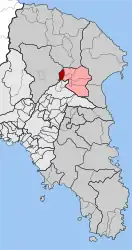 | |
| Coordinates: 38°8′N 23°50′E / 38.133°N 23.833°E | |
| Country | Greece |
| Administrative region | Attica |
| Regional unit | East Attica |
| Municipality | Dionysos |
| • Municipal unit | 4.531 km2 (1.749 sq mi) |
| Elevation | 380 m (1,250 ft) |
| Population (2011)[1] | |
| • Municipal unit | 5,040 |
| • Municipal unit density | 1,100/km2 (2,900/sq mi) |
| Time zone | UTC+2 (EET) |
| • Summer (DST) | UTC+3 (EEST) |
| Postal code | 145 65 |
| Area code(s) | 210 |
| Vehicle registration | ZB-ZY |
| Website | www.kryoneri.gr |
Kryoneri (Greek: Κρυονέρι [kɾioˈneɾi], meaning "cold water") is a suburban town of Athens in East Attica, Greece. Since the 2011 local government reform it is part of the municipality Dionysos, of which it is a municipal unit.[2] The municipal unit has an area of 4.531 km2.[3]
Geography
Kryoneri is situated in the hills in the northeastern part of the Athens conurbation, at about 380 m elevation. It lies in the eastern foothills of the Parnitha mountains. It is 2 km west of Agios Stefanos and 20 km northeast of Athens city centre. Motorway 1 (Athens - Lamia - Thessaloniki) and the railway from Athens to Thessaloniki pass east of the town.
Historical population
Kryoneri has historically been an Arvanite settlement.[4]
| Year | Population |
|---|---|
| 1981 | 858 |
| 1991 | 1,261 |
| 2001 | 2,721 |
| 2011 | 5,040 |
| 2021 | 3,982 |
Notes
- ↑ "Απογραφή Πληθυσμού - Κατοικιών 2011. ΜΟΝΙΜΟΣ Πληθυσμός" (in Greek). Hellenic Statistical Authority.
- ↑ "ΦΕΚ B 1292/2010, Kallikratis reform municipalities" (in Greek). Government Gazette.
- ↑ "Population & housing census 1991 (incl. area and average elevation)" (in Greek). National Statistical Service of Greece.
- ↑ Hans-Jürgen Sasse (1991). Arvanitika: die albanischen Sprachreste in Griechenland. Vol. 1. p. 18. ISBN 9783447027588.
External links
- Official website (in Greek)
- GTP Travel Pages (Municipality) (in English and Greek)
Places adjacent to Kryoneri, Attica | ||||||||||||||||
|---|---|---|---|---|---|---|---|---|---|---|---|---|---|---|---|---|
| ||||||||||||||||
This article is issued from Wikipedia. The text is licensed under Creative Commons - Attribution - Sharealike. Additional terms may apply for the media files.