| Kunchikal Falls | |
|---|---|
 | |
| Location | Nidagodu village, near Masthikatte, Shimoga district, Karnataka |
| Coordinates | 13°41′41″N 75°01′05″E / 13.6947°N 75.01813°E |
| Type | Tiered |
| Total height | 1493 ft (455m)[1] |
| Number of drops | 4 |
| Watercourse | Varahi River |
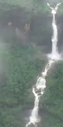
Kunchikal Falls is a waterfall in India located in the Nidagodu village near Masthikatte in the Shimoga district of state Karnataka.[2][3] Kunchikal falls cascades down rocky boulders and the total height of the falls is 455 meters (1493 feet) according to the World Waterfall Database.[1] Kunchikal falls is formed by the Varahi river.
After the construction of the Mani Dam near Masthikatte[4] and an underground power generation station[4] near Hulikal, Shimoga district, the water flow to the falls is greatly reduced and is visible only during the rainy season (July-Sept). As the falls are within a restricted area, a gate pass is required to visit. The nearest Airport is at Mangalore, situated 138 km (86 mi) from Kunchikal Falls.[5]
See also
References
- 1 2 "Kunchikal Falls Karnataka, India - World Waterfall Database". Worldwaterfalldatabase.com. Retrieved 3 January 2021.
- ↑ Husain, Majid (1978). Geography Of India. New Delhi: Tata McGraw-Hill Education. p. 3.47. ISBN 978-1-259-00089-8.
- ↑ "Tallest and Largest Waterfalls at the World Waterfall Database".
- 1 2 "Varahi Hydro Electric Project". Karnataka Power Corporation Limited. Archived from the original on 29 November 2012. Retrieved 3 August 2012.
- ↑ "138 Km - Distance from Mangalore to Kunchikal Falls". DistancesFrom. Retrieved 7 October 2017.
External links
This article is issued from Wikipedia. The text is licensed under Creative Commons - Attribution - Sharealike. Additional terms may apply for the media files.