Kupiškis District Municipality
Kupiškio rajono savivaldybė | |
|---|---|
.jpg.webp) Kupa is a river flowing through Kupiškis | |
 Coat of arms | |
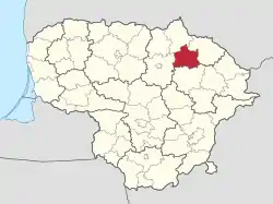 Location of Kupiškis district municipality within Lithuania | |
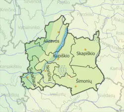 Map of Kupiškis district municipality | |
| Country | |
| Ethnographic region | Aukštaitija |
| County | |
| Capital | Kupiškis |
| Elderships | 6 |
| Area | |
| • Total | 1,080 km2 (420 sq mi) |
| • Rank | 37th |
| Population (2021[1]) | |
| • Total | 16,530 |
| • Rank | 50th |
| • Density | 15/km2 (40/sq mi) |
| • Rank | 48th |
| Time zone | UTC+2 (EET) |
| • Summer (DST) | UTC+3 (EEST) |
| Telephone code | 459 |
| Major settlements |
|
| Website | www |
Kupiškis District Municipality is one of 60 municipalities in Lithuania.
References

55°49′59″N 25°01′08″E / 55.83306°N 25.01889°E
This article is issued from Wikipedia. The text is licensed under Creative Commons - Attribution - Sharealike. Additional terms may apply for the media files.