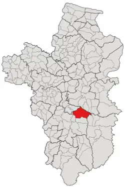
Kut Prathai
กุดประทาย | |
|---|---|
 Subdistrict location in Ubon Ratchathani province | |
| Country | Thailand |
| Province | Ubon Ratchathani |
| District | Det Udom |
| Mubans | 19 |
| Mu | 21 |
| Subdistrict established | 1947 |
| Area | |
| • Total | 151.776 km2 (58.601 sq mi) |
| Population (2021) | |
| • Total | 13,687 |
| • Density | 90.18/km2 (233.6/sq mi) |
| Time zone | UTC+7 (ICT) |
| Postal code | 34160 |
Kut Prathai (Thai: กุดประทาย) is a tambon (subdistrict) of Det Udom District, in Ubon Ratchathani Province, Thailand.[1] In 2021, it had a population of 13,687 people.[2] Neighbouring subdistricts are (clockwise from the south) Kham Khrang, Phon Ngam, Mueang Det, Na Rueang, Na Yia, Nong Bua Hi, Ban Khaem, Ang Sila and Na Pho.[1]
History
Kut Prathai legally gained subdistrict status in 1947. Previously, it was administered by the district's capital, Mueang Det.[3] In 1980, the southern region of the tambon was split off to establish a new tambon, Kham Khrang.[4]
Geography
The tambon is located in the northeastern region of Det Udom district, which is the river plain of the Lam Dom Yai river (ลำโดมใหญ่).[1]
Administration
The tambon is divided into nineteen administrative villages (mubans; หมู่บ้าน) which are further divided into twenty-one community groups (Mu; หมู่).[2] All of which were governed by the Kut Prathai subdistrict municipality (เทศบาลตำบลกุดประทาย).[1][2]
The following is a list of the subdistrict's mubans, which roughly correspond to the villages:[2]
| Village | Group (Mu) | Household (as of 2021) | Population (as of 2021) | |
|---|---|---|---|---|
| Romanized name | Thai name | |||
| Non Kham | โนนขาม | 1 | 221 | 684 |
| Don Muay | ดอนม่วย | 2 | 163 | 391 |
| Na Thung | นาทุ่ง | 3 | 291 | 679 |
21 | 117 | 350 | ||
| Non Koy | โนนกอย | 4 | 299 | 880 |
| Kut Prathai | กุดประทาย | 5 | 336 | 586 |
| Nong Khu | หนองคู | 6 | 303 | 813 |
| Non Kheng | โนนเค็ง | 7 | 225 | 690 |
| Sook Somboon | สุขสมบูรณ์ | 8 | 335 | 940 |
| Kham Naseang | คำนาแซง | 9 | 429 | 1,195 |
| Non Bok | โนนบก | 10 | 176 | 500 |
| Saen Sook | แสนสุข | 11 | 258 | 634 |
20 | 258 | 702 | ||
| Udom Sook | อุดมสุข | 12 | 277 | 559 |
| Hlao | เหล่า | 13 | 276 | 685 |
| Nong Waeng | หนองแวง | 14 | 104 | 404 |
| Kut Charoen | กุดเจริญ | 15 | 357 | 752 |
| Non Charoen | โนนเจริญ | 16 | 219 | 802 |
| Seam Chacoen | เสียมเจริญ | 17 | 123 | 375 |
| Thung Saeng Tawan | ทุ่งแสงตะวัน | 18 | 155 | 484 |
| Kham Na Saeng | คำนาแซง | 19 | 193 | 506 |
| Central house Registration | 1 | 76 | ||
| Total | 5,116 | 13,687 | ||
References
- 1 2 3 4 "สภาพทั่วไป". Kudprathay.go.th (in Thai). Kut Prathai subdistrict municipality. Archived from the original on 3 July 2022. Retrieved 15 December 2022.
- 1 2 3 4 "โครงสร้างข้อมูลสถิติจำนวนประชากร" (in Thai). Department of Provincial Administration of Thailand. 2021. Archived from the original on 22 December 2022. Retrieved 15 December 2022.
{{cite web}}: CS1 maint: bot: original URL status unknown (link) - ↑ "ประวัติความเป็นมา". Kudprathay.go.th. Kut Prathai subdistrict municipality. Archived from the original on 3 July 2022.
- ↑ "ประวัติความเป็นมา". www.khamkhrang.go.th (in Thai). Subdistrict Administrative Organization of Kham Khrang. Archived from the original on 17 June 2022. Retrieved 15 December 2022.
14°57′33″N 105°10′33″E / 14.959094°N 105.175818°E