| Kyrkjetaket | |
|---|---|
| Kirketaket | |
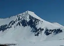
 Kyrkjetaket as seen from the topp of Kjøvskartind | |
| Highest point | |
| Elevation | 1,439 m (4,721 ft) |
| Prominence | 210 m (690 ft) |
| Coordinates | 62°36′43″N 07°54′08″E / 62.61194°N 7.90222°E |
| Geography | |
 Kyrkjetaket Location in Møre og Romsdal  Kyrkjetaket Kyrkjetaket (Norway) | |
| Location | Rauma, Møre og Romsdal, Norway |
| Parent range | Romsdalsalpene |
| Topo map | 1320 II Eresfjord |
Kyrkjetaket or Kirketaket is a mountain on the border of the municipalities of Rauma and Nesset in Møre og Romsdal county, Norway. The 1,439-metre (4,721 ft) tall peak is located in Rauma, about 7 kilometres (4.3 mi) northeast of the village of Isfjorden and 12.4 kilometres (7.7 mi) from the town of Åndalsnes. The mountain Gjuratinden lies about 9 kilometres (5.6 mi) southeast of Kyrkjetaket. The name Kyrkjetaket translates to "the Church roof".
Kyrkjetaket seen from Hestberget, along winter route to the summit.

Skarven (from left), Kirketaket and Kjøvskartind, from Åndalsnes.
In February 2004, it was chosen as one of Norway's 10 finest alpine mountains by the magazine Fri Flyt.[1]
See also
References
- ↑ "Kirketaket in Isfjorden". Retrieved 2010-10-26.
This article is issued from Wikipedia. The text is licensed under Creative Commons - Attribution - Sharealike. Additional terms may apply for the media files.