La Martre | |
|---|---|
.jpg.webp) La Martre Lighthouse | |
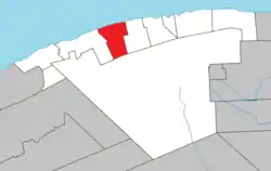
 Location within La Haute-Gaspésie RCM. | |
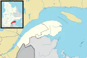
 La Martre Location in eastern Quebec. | |
| Coordinates: 49°10′N 66°10′W / 49.167°N 66.167°W[1] | |
| Country | |
| Province | |
| Region | Gaspésie–Îles-de-la-Madeleine |
| RCM | La Haute-Gaspésie |
| Constituted | December 18, 1923 |
| Government | |
| • Mayor | Claudette Robinson |
| • Federal riding | Haute-Gaspésie—La Mitis—Matane—Matapédia |
| • Prov. riding | Gaspé |
| Area | |
| • Total | 177.60 km2 (68.57 sq mi) |
| • Land | 175.23 km2 (67.66 sq mi) |
| Population | |
| • Total | 194 |
| • Density | 1.1/km2 (3/sq mi) |
| • Pop 2016-2021 | |
| • Dwellings | 119 |
| Time zone | UTC−5 (EST) |
| • Summer (DST) | UTC−4 (EDT) |
| Postal code(s) | |
| Area code(s) | 418 and 581 |
| Highways | |
La Martre is a municipality in the Gaspésie-Îles-de-la-Madeleine region of the province of Quebec in Canada.
In addition to La Martre itself, the municipality also includes the communities of Cap-au-Renard, Christie, and Sainte-Marthe-de-Gaspé.[5]
History

The area saw permanent settlement in the late 19th century and was originally called Rivière-à-la-Marthe, after the Marten River (French: Rivière à la Marthe) that flows into the Gulf of Saint Lawrence there. The marten is found along this river's banks and is abundant in the Gaspé region.[1]
In 1923, the place separated from the municipality of Sainte-Anne-des-Monts to form the Township Municipality of Christie, named in honour of Robert Christie. In 1950, the township municipality was split in two when Marsoui was incorporated as a village municipality.[6]
In 1970, the municipality was renamed to La Martre.[1]
Demographics

Population
| 2021 | 2016 | 2011 | |
|---|---|---|---|
| Population | 194 (-20.2% from 2016) | 243 (-0.8% from 2011) | 245 (-3.2% from 2006) |
| Land area | 175.23 km2 (67.66 sq mi) | 175.46 km2 (67.75 sq mi) | 173.24 km2 (66.89 sq mi) |
| Population density | 1.1/km2 (2.8/sq mi) | 1.4/km2 (3.6/sq mi) | 1.4/km2 (3.6/sq mi) |
| Median age | 55.2 (M: 57.2, F: 48.0) | 52.1 (M: 51.8, F: 53.0) | 50.2 (M: 50.2, F: 50.2) |
| Private dwellings | 119 (total) 84 (occupied) | 147 (total) | 184 (total) |
| Median household income | $45,184 | $.N/A |
|
|
|
Gallery
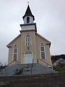
 La Martre Lighthouse, built in 1906
 Cap-au-Renard
See also
References
- 1 2 3 "La Martre (Municipalité)" (in French). Commission de toponymie du Québec. Retrieved 2011-12-19.
- 1 2 "La Martre". Répertoire des municipalités (in French). Ministère des Affaires municipales, des Régions et de l'Occupation du territoire. Archived from the original on 2012-06-07. Retrieved 2011-12-19.
- ↑ "Profil du recensement, Recensement de 2021, Statistique Canada - Erreur de validation".
- ↑ "Profil du recensement, Recensement de 2021, Statistique Canada - Erreur de validation".
- ↑ "Toponyms". Le directeur général des élections du Québec (Quebec election office). 24 August 2009. Retrieved 2010-03-11.
- ↑ "Municipalité, historique" (in French). Municipalité de Marsoui. Retrieved 2011-12-16.
- ↑ "2021 Community Profiles". 2021 Canadian Census. Statistics Canada. February 4, 2022. Retrieved 2023-10-19.
- ↑ "2016 Community Profiles". 2016 Canadian Census. Statistics Canada. August 12, 2021. Retrieved 2022-07-14.
- ↑ "2011 Community Profiles". 2011 Canadian Census. Statistics Canada. March 21, 2019. Retrieved 2013-05-14.
- ↑ "2006 Community Profiles". 2006 Canadian Census. Statistics Canada. August 20, 2019.
- ↑ "2001 Community Profiles". 2001 Canadian Census. Statistics Canada. July 18, 2021.
- ↑ Statistics Canada: 1996, 2001, 2006, 2011, 2016, 2021 census