Lac de la Haute-Sûre
Stauséigemeng | |
|---|---|
 | |
 Coat of arms | |
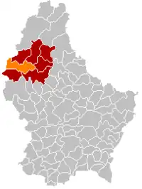 Map of Luxembourg with Lac de la Haute-Sûre highlighted in orange, and the canton in dark red | |
| Coordinates: 49°55′12″N 5°50′49″E / 49.92°N 5.8469°E | |
| Country | |
| Canton | Wiltz |
| Area | |
| • Total | 48.5 km2 (18.7 sq mi) |
| • Rank | 10th of 102 |
| Highest elevation | 537 m (1,762 ft) |
| • Rank | 7th of 102 |
| Lowest elevation | 284 m (932 ft) |
| • Rank | 86th of 102 |
| Population (2023) | |
| • Total | 2,253 |
| • Rank | 77th of 102 |
| • Density | 46/km2 (120/sq mi) |
| • Rank | 99th of 102 |
| Time zone | UTC+1 (CET) |
| • Summer (DST) | UTC+2 (CEST) |
| LAU 2 | LU0000806 |
| Website | lac-haute-sure.lu |
Lac de la Haute-Sûre (Luxembourgish: Stauséigemeng), (German: Stauseegemeinde) is a commune, in the canton of Wiltz in north-western Luxembourg. The commune is named after the Upper Sûre Lake, a reservoir on the upper Sauer river. The commune's administrative centre is Bavigne.
Lac de la Haute-Sûre was formed on 1 January 1979 from the former communes of Harlange and Mecher, both in Wiltz canton. The law creating Lac de la Haute-Sûre was passed on 23 December 1978.[1]
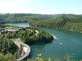
The Upper Sûre Lake, after which the commune is named
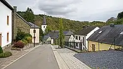
Populated places
The commune consists of the following villages:
Population
References
- ↑ "Mémorial A, 1978, No. 89" (PDF) (in French). Service central de législation. Archived from the original (PDF) on 29 October 2005. Retrieved 11 August 2006.
- ↑ "Population par canton et commune". statistiques.public.lu. Archived from the original on 12 September 2016. Retrieved 11 January 2022.
External links
 Media related to Lac de la Haute-Sûre at Wikimedia Commons

Places adjacent to Lac de la Haute-Sûre | |
|---|---|
Wikimedia Commons has media related to Lac de la Haute-Sûre.
This article is issued from Wikipedia. The text is licensed under Creative Commons - Attribution - Sharealike. Additional terms may apply for the media files.