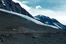
Lacroix Glacier in 1958
Lacroix Glacier (77°40′S 162°33′E / 77.667°S 162.550°E) is a glacier between Suess Glacier and Matterhorn Glacier, which flows southeast into Taylor Valley in Victoria Land, Antarctica. It was mapped by the British Antarctic Expedition, 1910–13, under Robert Falcon Scott, and named after Alfred Lacroix, as was Mount Lacroix.[1]
References
- ↑ "Lacroix Glacier". Geographic Names Information System. United States Geological Survey, United States Department of the Interior. Retrieved 23 May 2013.
![]() This article incorporates public domain material from "Lacroix Glacier". Geographic Names Information System. United States Geological Survey.
This article incorporates public domain material from "Lacroix Glacier". Geographic Names Information System. United States Geological Survey.
This article is issued from Wikipedia. The text is licensed under Creative Commons - Attribution - Sharealike. Additional terms may apply for the media files.