| Laguna Redonda | |
|---|---|
 | |
| Location | Concepción, Chile |
| Coordinates | 36°48′50″S 73°02′40″W / 36.81389°S 73.04444°W |
| Max. width | 207 m (679 ft) |
| Surface area | 41,000 m2 (440,000 sq ft) |
| Max. depth | 19 m (62 ft) |
| Water volume | 410,000 m3 (14,000,000 cu ft) |
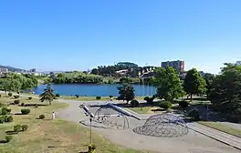
The Redonda Lagoon (Spanish: Laguna Redonda) is a lagoon located in the city of Concepción, Chile. It covers a surface of 41,000 square metres (440,000 sq ft) m² and contains the deepest lagoon of all the city, with a depth of 19 m.[1]
Geography
Laguna Redonda is located about 1 kilometre (0.62 mi) of distance of the River Biobío, on the west of the hill Chepe and the northwest at of the Laguna Lo Galindo.[1] The name "Redonda" is due to its circular shape, with an average diameter of 207 metres (226 yd). The Redonda lagoon is home to vast mangrove swamps consisting of four different species, with the red mangrove (Rhizophora mangle) being the most prevalent.[2]
History
At the beginning of the 20th century, the lagoon was the halfway between Concepción and Talcahuano.[3] It was part of the tram that worked between 1908 and 1941.[4] In that period, the lagoon was surrounded by golf courses of the British colony, and by several fundos and quintas that provided to the local industry raw materials.[3]
Today, it is located in Lorenzo Arenas, a sector in the city of Concepción.[1]
See also
References
- 1 2 3 "Lagunas urbanas del Gran Concepción" (PDF). Retrieved 20 May 2016.
- ↑ "Refugio de Vida Silvestre Laguna Redonda y Limón (Los Humedales del Refugio de Vida Silvestre Laguna Redonda y Limón, Miches y Ria Maimón) | Ramsar Sites Information Service". rsis.ramsar.org. Retrieved 2023-07-16.
- 1 2 "Tranvía y Concepción". Retrieved 20 May 2016.
- ↑ "Década de 1940". Archived from the original on 5 September 2013. Retrieved 20 May 2016.