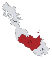
| Lalmonirhat-2 | |
|---|---|
| Constituency for the Jatiya Sangsad | |
 | |
| District | Lalmonirhat District |
| Division | Rangpur Division |
| Electorate | 346,334 (2018)[1] |
| Current constituency | |
| Created | 1984 |
| Party | AL |
| Member(s) | Nuruzzaman Ahmed |
| Seat no. 17 | |
Lalmonirhat-2 is a constituency represented in the Jatiya Sangsad (National Parliament) of Bangladesh since 2014 by Nuruzzaman Ahmed of the Awami League.
Boundaries
The constituency encompasses Aditmari and Kaliganj upazilas.[2][3]
History
The constituency was created in 1984 from the Rangpur-6 constituency when the former Rangpur District was split into five districts: Nilphamari, Lalmonirhat, Rangpur, Kurigram, and Gaibandha.
Members of Parliament
Elections
Elections in the 2010s
Nuruzzaman Ahmed was elected unopposed in the 2014 general election after opposition parties withdrew their candidacies in a boycott of the election.[8]
Elections in the 2000s
| Party | Candidate | Votes | % | ±% | ||
|---|---|---|---|---|---|---|
| JP(E) | Mojibur Rahman | 161,677 | 69.4 | N/A | ||
| BNP | Saleh Uddin Ahmed | 61,599 | 26.4 | +2.2 | ||
| IAB | Md. Ebrahim Hossain Khan | 9,692 | 4.2 | N/A | ||
| Majority | 100,078 | 43.0 | +41.2 | |||
| Turnout | 232,968 | 86.6 | +14.3 | |||
| JP(E) gain from IJOF | ||||||
| Party | Candidate | Votes | % | ±% | ||
|---|---|---|---|---|---|---|
| IJOF | Mojibur Rahman | 60,468 | 34.5 | N/A | ||
| Independent | Nuruzzaman Ahmed | 57,265 | 32.7 | N/A | ||
| BNP | Saleh Uddin Ahmed | 42,298 | 24.2 | +13.7 | ||
| AL | Md. Emdadul Haque Chowdhury | 14,309 | 8.2 | -28.1 | ||
| Jatiya Party (M) | Hasan Shahid Monju | 787 | 0.4 | N/A | ||
| Majority | 3,203 | 1.8 | -4.1 | |||
| Turnout | 175,127 | 72.3 | +2.2 | |||
| IJOF gain from JP(E) | ||||||
Elections in the 1990s
| Party | Candidate | Votes | % | ±% | |
|---|---|---|---|---|---|
| JP(E) | Mojibur Rahman | 57,804 | 42.2 | -4.1 | |
| AL | Nuruzzaman Ahmed | 49,683 | 36.3 | -1.6 | |
| BNP | Md. Abdul Mannan Sarkar | 14,399 | 10.5 | +4.7 | |
| Jamaat-e-Islami | Md. Samsul Haque | 11,713 | 8.5 | +0.7 | |
| Independent | Md. Fazlur Rahman | 2,302 | 1.7 | N/A | |
| Gano Forum | Md. Emdadul Haque | 709 | 0.5 | N/A | |
| Zaker Party | Md. Rezaul Karim Manik | 402 | 0.3 | -0.1 | |
| Majority | 8,121 | 5.9 | -2.5 | ||
| Turnout | 137,012 | 70.1 | +15.0 | ||
| JP(E) hold | |||||
| Party | Candidate | Votes | % | ±% | |
|---|---|---|---|---|---|
| JP(E) | Mojibur Rahman | 51,755 | 46.3 | ||
| AL | Shamsul Islam | 42,413 | 37.9 | ||
| Jamaat-e-Islami | Md. Abdul Wares | 8,715 | 7.8 | ||
| BNP | Abdul Hamid | 6,474 | 5.8 | ||
| IOJ | Md. Sultan Ahmed | 1,352 | 1.2 | ||
| Zaker Party | Md. Kazi Altafur Rahman | 447 | 0.4 | ||
| WPB | Md. Kamrul Hasan Siddique | 341 | 0.3 | ||
| Independent | Shree Jitindro Nath | 294 | 0.3 | ||
| Majority | 9,342 | 8.4 | |||
| Turnout | 111,791 | 55.1 | |||
| JP(E) hold | |||||
References
- ↑ "Lalmonirhat-2". The Daily Star. Retrieved 31 December 2018.
- 1 2 "Constituency Maps of Bangladesh" (PDF). Bangladesh Election Commission. 2010. Archived from the original (PDF) on 14 August 2014. Retrieved 13 August 2014.
- ↑ "Delimitation of Constituencies" (PDF). Bangladesh Election Commission (in Bengali). 2013. Archived from the original (PDF) on 27 July 2014. Retrieved 23 July 2014.
- ↑ "List of 3rd Parliament Members" (PDF). Bangladesh Parliament (in Bengali). Retrieved 13 August 2014.
- ↑ "List of 4th Parliament Members" (PDF). Bangladesh Parliament (in Bengali). Retrieved 13 August 2014.
- ↑ "List of 6th Parliament Members" (PDF). Jatiya Sangsad. Archived (PDF) from the original on 15 September 2018. Retrieved 9 April 2020.
- ↑ "List of 7th Parliament Members" (PDF). Bangladesh Parliament. Archived from the original (PDF) on 24 September 2015. Retrieved 24 August 2019.
- ↑ Ahmed, Taib (15 December 2013). "AL closer to majority before voting". New Age. Dhaka. Retrieved 12 August 2014.
- ↑ "Bangladesh Parliament Election - Detail Results". Amar Desh. Retrieved 8 February 2018.
- ↑ "Nomination submission List". Bangladesh Election Commission (in Bengali). Archived from the original on 11 February 2018. Retrieved 9 February 2018.
- 1 2 3 "Parliament Election Result of 1991,1996,2001 Bangladesh Election Information and Statistics". Vote Monitor Networks. Archived from the original on 24 December 2008. Retrieved 11 February 2018.
External links
25°58′N 89°13′E / 25.97°N 89.22°E
This article is issued from Wikipedia. The text is licensed under Creative Commons - Attribution - Sharealike. Additional terms may apply for the media files.