Lang Suan
หลังสวน | |
|---|---|
.jpg.webp) Beach at Bang Nam Chuet | |
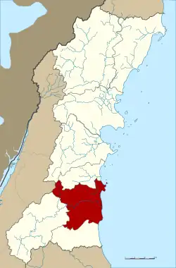 District location in Chumphon province | |
| Coordinates: 9°56′44″N 99°4′43″E / 9.94556°N 99.07861°E | |
| Country | Thailand |
| Province | Chumphon |
| Seat | Khan Ngoen |
| Area | |
| • Total | 935.0 km2 (361.0 sq mi) |
| Population (2007) | |
| • Total | 70,837 |
| • Density | 75.8/km2 (196/sq mi) |
| Time zone | UTC+7 (ICT) |
| Postal code | 86110 |
| Geocode | 8604 |
Lang Suan (Thai: หลังสวน, pronounced [lǎŋ sǔa̯n]) is a district (amphoe) of Chumphon province, southern Thailand.
History
Lang Suan was originally a mueang reporting directly to Bangkok. During the Thesaphiban reforms at the end of the 19th century it was put under monthon Chumphon. On 29 April 1917 the district's name was changed from Mueang Lang Suan to Khan Ngein (ขันเงิน).[1] On 1 April 1932 the province was abolished and its districts were incorporated into Chumphon province.[2] On 14 November 1938 the district's name was changed to Lang Suan (หลังสวน).[3]
Geography
Neighboring districts are (from the south clockwise) Lamae and Phato of Chumphon Province, La-un of Ranong province, and Sawi and Thung Tako of Chumphon. To the east is the Gulf of Thailand.
Administration
The district is divided into 13 sub-districts (tambons), which are further subdivided into 147 villages (mubans). The town (thesaban mueang) Lang Suan includes the tambon Lang Suan and parts of Khan Ngoen, Pho Daeng, Laem Sai, and Wang Tako. The sub-district municipality (thesaban tambon) Paknam Lang Suan includes tambon Pak Nam. There are a further 12 tambon administrative organizations (TAO).
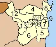
| No. | Name | Thai | Villages | Pop. |
|---|---|---|---|---|
| 1. | Lang Suan | หลังสวน | - | 3,914 |
| 2. | Khan Ngein | ขันเงิน | 7 | 7,460 |
| 3. | Tha Maphla | ท่ามะพลา | 9 | 3,090 |
| 4. | Na Kha | นาขา | 13 | 7,768 |
| 5. | Na Phaya | นาพญา | 19 | 5,017 |
| 6. | Ban Khuan | บ้านควน | 17 | 7,859 |
| 7. | Bang Maphrao | บางมะพร้าว | 14 | 4,628 |
| 8. | Bang Nam Chuet | บางน้ำจืด | 14 | 4,851 |
| 9. | Paknam | ปากน้ำ | 6 | 6,843 |
| 10. | Pho Daeng | พ้อแดง | 10 | 2,237 |
| 11. | Laem Sai | แหลมทราย | 12 | 3,694 |
| 12. | Wang Tako | วังตะกอ | 13 | 7,285 |
| 13. | Hat Yai | หาดยาย | 13 | 6,191 |
References
- ↑ "ประกาศเรื่องเปลียนชืออำเภอ" [Notice of changing district name] (PDF). Royal Thai Government Gazette. 34: 40–68. 29 April 1917. Archived from the original (PDF) on November 7, 2011. Retrieved 15 November 2019, page 51
{{cite journal}}: CS1 maint: postscript (link) - ↑ "ประกาศ เรื่องยุบรวมท้องทีบางมณฑลและบางจังหวัด" [Notice: Abolition of some monthons and provinces] (PDF). Royal Thai Government Gazette. 48: 576–578. 21 February 1931. Archived from the original (PDF) on April 9, 2008. Retrieved 16 April 2020, Changwat 5
{{cite journal}}: CS1 maint: postscript (link) - ↑ "พระราชกฤษฎีกา เปลี่ยนนามจังหวัด และอำเภอบางแห่ง พุทธศักราช ๒๔๘๑" [Royal Decree: Change name of Provinces and Districts] (PDF). Royal Thai Government Gazette. 55: 658–666. 14 November 1938. Archived from the original (PDF) on November 8, 2011. Retrieved 20 April 2020, page 660
{{cite journal}}: CS1 maint: postscript (link)
External links
| Historical divisions |
| ||||
|---|---|---|---|---|---|
| Former provinces |
| ||||