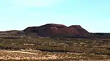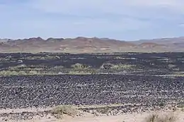

The Lavic Lake volcanic field is a volcanic field with extinct cinder cones in the Mojave Desert, in San Bernardino County, California, United States, at 762 m (2,500 ft) elevation. Its cones lie directly alongside historic Route 66 and modern Interstate 40, between Barstow to the west and Ludlow 10 miles (16 km) to the east.[1]
Description
The 100 km2 (39 sq mi) Lavic Lake volcanic field is a basaltic pahoehoe lava plain and has four Holocene (approximately 10,000 years ago) cinder cone type volcanos, three in the Lavic Dry Lake area, and a fourth located southwest in the Rodman Mountains.[1][2] The oldest cinder cone, Pisgah Crater may be pre-Holocene, erupting around 25,000 years ago.[2]
Of the four cinder cones, Pisgah Crater stands as the most accessible and prominent volcano in the volcanic field with a height of 100 m (330 ft) above the field with a peak elevation of 2,545 feet (776 m), at 34°44′47″N 116°22′30″W / 34.74639°N 116.37500°W. The cone of Pisgah Crater has been modified by mining operations that provide a source of road aggregate.[1]
The biome is the deserts and xeric shrublands, with smaller plants growing in soil pockets formed by erosion, sedimentation and wind deposits.
See also
References
- 1 2 3 Global Volcanism Program, 2013. Lavic Lake (323190) in Volcanoes of the World, v. 4.6.7. Venzke, E (ed.). Smithsonian Institution. Downloaded 15 May 2018 (http://volcano.si.edu/volcano.cfm?vn=323190). https://doi.org/10.5479/si.GVP.VOTW4-2013
- 1 2 "Lavic Lake Volcanic Field". United States Geological Survey. Retrieved 2012-02-13.
External links
- "Lavic Lake". Global Volcanism Program. Smithsonian Institution. Retrieved 2021-06-28.
34°44′47″N 116°22′30″W / 34.74639°N 116.37500°W