| Layou River | |
|---|---|
 Layou River | |
 Location of mouth | |
| Location | |
| Country | Dominica |
| Physical characteristics | |
| Mouth | Caribbean Sea |
• coordinates | 15°23′N 61°26′W / 15.383°N 61.433°W |
| Length | 27.6 km (17.1 mi) |
| Basin size | 74.3 km2 (28.7 sq mi) |
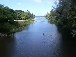
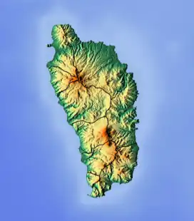
The Layou River is a river in Dominica. It rises in the interior of the country, flowing westward to reach the Caribbean Sea on the country's central western coast, very close to the town of St. Joseph. It is the longest and deepest river in Dominica. With a total length of 27.6 km (17.1 mi) long.
Disaster
The river is prone to flooding. Matthieu Dam, which is located near the end of the river, has collapsed multiple times. It started in the year 1997 when landslides, due to heavy rainfall blocked portions of the river.[1] In the year 2011, the river flooded twice, in July[2] and October.[3] This poses a major threat to the Layou village. There were no deaths, but it affected 13 dwellings.[4]
References
- ↑ "Progress Bulletin: Post-disaster Response: Landslide Dam in the Layou River, Dominica". www.oas.org. Retrieved 2016-10-10.
- ↑ "Ecological Disaster Area Declared for Layou River Valley, Dominica". www.cdema.org. Retrieved 2016-10-10.
- ↑ "UPDATE: Flooding in Layou – again". Dominica News Online. Retrieved 2016-10-10.
- ↑ "Ecological Disaster Area Declared for Layou River Valley, Dominica". www.cdema.org. Retrieved 2016-10-10.
External links
 Media related to Layou River at Wikimedia Commons
This article is issued from Wikipedia. The text is licensed under Creative Commons - Attribution - Sharealike. Additional terms may apply for the media files.