| Leckner Ach Lecknerbach | |
|---|---|
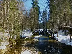
 The Leckner Ach near Hittisau | |
| Location | |
| Countries | Austria and Germany |
| States | Voralberg and Bavaria |
| Reference no. | DE: 214622, AT: 8111441422 |
| Physical characteristics | |
| Source | |
| • location | On the northwest slopes of the Girenkopf |
| • coordinates | 47°28′51″N 10°06′11″E / 47.48083°N 10.10306°E |
| • elevation | ca. 1,600 m above sea level (NN) |
| Mouth | |
• location | East of Hittisau into the Bolgenach |
• coordinates | 47°27′34″N 9°59′48″E / 47.459583°N 09.99667°E |
• elevation | ca. 790 m (AA) |
| Length | 10.0 km (6.2 mi) [1] |
| Basin features | |
| Progression | Bolgenach→ Weißach→ Bregenzer Ach→ Lake Constance→ Rhine→ North Sea |
The Leckner Ach, also called the Lecknerbach, is a river of Voralberg, Austria and of Bavaria, Germany. It is a right-hand tributary of the Bolgenach east of Hittisau, and about 9 kilometres (5.6 mi) long.
See also
References
- ↑ Complete table of the Bavarian Waterbody Register by the Bavarian State Office for the Environment (xls, 10.3 MB)
This article is issued from Wikipedia. The text is licensed under Creative Commons - Attribution - Sharealike. Additional terms may apply for the media files.