| Lehrde | |
|---|---|
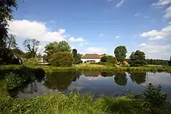
 The dammed Lehrde at Stellichte (Walsrode) | |
| Location | |
| Country | Germany |
| State | Lower Saxony |
| Physical characteristics | |
| Source | |
| • location | east of Kettenburg |
| • coordinates | 52°57′16″N 9°35′46″E / 52.95444°N 9.59611°E |
| • elevation | 66 m above sea level (NN) |
| Mouth | |
• location | south of Hohenaverbergen |
• coordinates | 52°51′55″N 9°18′02″E / 52.865222°N 9.3006°E |
• elevation | 14 m above sea level (NN) |
| Length | 32.0 km (19.9 mi) [1] |
| Basin size | 190 km2 (73 sq mi) [1] |
| Basin features | |
| Progression | Aller→ Weser→ North Sea |
| Landmarks | Villages: Kettenburg, Stellichte, Lehrden, Stemmen, Wittlohe, |
| Tributaries | |
| • left | Fahlbeeke, Idsinger Bach, Hammwieder Graben, Vethbach, Otersener Entwässerungsgraben |
| • right | Wehnser Bach, Bleckwedeler Graben |
The Lehrde is a 32 km (20 mi) long, right tributary of the river Aller in Lower Saxony, Germany.
Course
It rises east of Kettenburg, a borough of Visselhövede, in the Öttinger Ochsenmoor nature reserve. It then heads westward, crossing the district of Heidekreis, passing the villages of Stellichte (part of Walsrode) and Lehrden. The Lehrde continues across the southern part of the district of Verden. Northeast of Wittlohe (part of Kirchlinteln) it is joined from the left by the Vethbach and discharges south of Hohenaverbergen (part of Kirchlinteln) into the Aller.
Culture
The setting for the fairy tale of the Town Musicians of Bremen is along part of the river Lehrde.
See also
References
External links
This article is issued from Wikipedia. The text is licensed under Creative Commons - Attribution - Sharealike. Additional terms may apply for the media files.