Leskensky District
Лескенский район | |
|---|---|
| Other transcription(s) | |
| • Kabardian | Лэскэн къедзыгъуэ |
| • Karachay-Balkar | Лескен район |
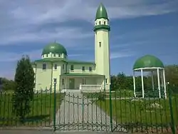
 Central Mosque, Argudana, Lesensky District | |
 Flag | |
Location of Leskensky District in the Kabardino-Balkar Republic | |
| Coordinates: 43°21′N 43°56′E / 43.350°N 43.933°E | |
| Country | Russia |
| Federal subject | Kabardino-Balkar Republic[1] |
| Established | 2003 |
| Administrative center | Anzorey[1] |
| Area | |
| • Total | 523.06 km2 (201.95 sq mi) |
| Population | |
| • Total | 27,840 |
| • Estimate (2018)[3] | 29,435 (+5.7%) |
| • Density | 53/km2 (140/sq mi) |
| • Urban | 0% |
| • Rural | 100% |
| Administrative structure | |
| • Inhabited localities[1] | 9 Rural localities |
| Municipal structure | |
| • Municipally incorporated as | Leskensky Municipal District[4] |
| • Municipal divisions[4] | 0 Urban settlements, 9 Rural settlements |
| Time zone | UTC+3 (MSK |
| OKTMO ID | 83618000 |
| Website | |
Leskensky District (Russian: Лескенский райо́н; Kabardian: Лэскэн къедзыгъуэ; Ossetian: Лескени уойлат; Karachay-Balkar: Лескен район) is an administrative[1] and a municipal[4] district (raion), one of the ten in the Kabardino-Balkar Republic, Russia. It is located in the southeast of the republic. The area of the district is 523.06 square kilometers (201.95 sq mi). Its administrative center is the rural locality (a selo) of Anzorey.[1] As of the 2010 Census, the total population of the district was 27,840, with the population of Anzorey accounting for 23.5% of that number.[2]
History
The district was established in 2003.
Administrative and municipal status
Within the framework of administrative divisions, Leskensky District is one of the ten in the Kabardino-Balkar Republic and has administrative jurisdiction over all of its nine rural localities.[1] As a municipal division, the district is incorporated as Leskensky Municipal District.[4] Its nine rural localities are incorporated into nine rural settlements within the municipal district.[4] The selo of Anzorey serves as the administrative center of both the administrative[1] and municipal[4] district.
References
Notes
- 1 2 3 4 5 6 7 Law #12-RZ
- 1 2 Russian Federal State Statistics Service (2011). Всероссийская перепись населения 2010 года. Том 1 [2010 All-Russian Population Census, vol. 1]. Всероссийская перепись населения 2010 года [2010 All-Russia Population Census] (in Russian). Federal State Statistics Service.
- ↑ "26. Численность постоянного населения Российской Федерации по муниципальным образованиям на 1 января 2018 года". Federal State Statistics Service. Retrieved January 23, 2019.
- 1 2 3 4 5 6 Law #13-RZ
- ↑ "Об исчислении времени". Официальный интернет-портал правовой информации (in Russian). June 3, 2011. Retrieved January 19, 2019.
Sources
- Парламент Кабардино-Балкарской Республики. Закон №12-РЗ от 27 февраля 2005 г. «Об административно-территориальном устройстве Кабардино-Балкарской Республики», в ред. Закона №20-РЗ от 23 апреля 2014 г. «О внесении изменений в отдельные республиканские Законы». Вступил в силу на следующий день после опубликования. Опубликован: "Кабардино-Балкарская правда", б/н, 1 марта 2005 г. (Parliament of the Kabardino-Balkarian Republic. Law #12-RZ of February 27, 2005 On the Administrative-Territorial Structure of the Kabardino-Balkarian Republic, as amended by the Law #20-RZ of April 23, 2014 On Amending Various Republican Laws. Effective as of the day following the publication date.).
- Парламент Кабардино-Балкарской Республики. Закон №13-РЗ от 27 февраля 2005 г. «Об статусе и границах муниципальных образований в Кабардино-Балкарской Республики», в ред. Закона №20-РЗ от 23 апреля 2014 г. «О внесении изменений в отдельные республиканские Законы». Вступил в силу на следующий день после официального опубликования. Опубликован: "Кабардино-Балкарская правда", б/н, 1 марта 2005 г. (Parliament of the Kabardino-Balkarian Republic. Law #13-RZ of February 27, 2005 On the Status and the Borders of the Municipal Formations in the Kabardino-Balkarian Republic, as amended by the Law #20-RZ of April 23, 2014 On Amending Various Republican Laws. Effective as of the day following the official publication date.).