Libavské Údolí | |
|---|---|
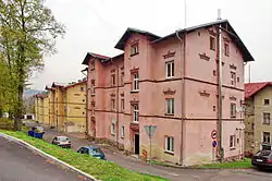 Houses in Libavské Údolí | |
 Flag  Coat of arms | |
 Libavské Údolí Location in the Czech Republic | |
| Coordinates: 50°7′44″N 12°33′9″E / 50.12889°N 12.55250°E | |
| Country | |
| Region | Karlovy Vary |
| District | Sokolov |
| First mentioned | 1829 |
| Area | |
| • Total | 2.29 km2 (0.88 sq mi) |
| Elevation | 442 m (1,450 ft) |
| Population (2023-01-01)[1] | |
| • Total | 531 |
| • Density | 230/km2 (600/sq mi) |
| Time zone | UTC+1 (CET) |
| • Summer (DST) | UTC+2 (CEST) |
| Postal code | 357 53 |
| Website | www |
Libavské Údolí (German: Liebauthal) is a municipality and village in Sokolov District in the Karlovy Vary Region of the Czech Republic. It has about 500 inhabitants.
References
Wikimedia Commons has media related to Libavské Údolí.
This article is issued from Wikipedia. The text is licensed under Creative Commons - Attribution - Sharealike. Additional terms may apply for the media files.