Linchuan
临川区 Linchwan | |
|---|---|
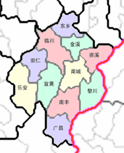
 Location in Fuzhou City | |
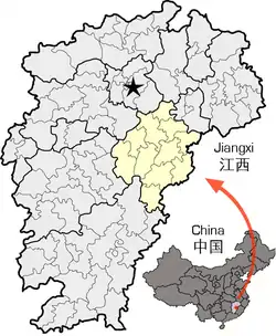
 Location of Fuzhou City in Jiangxi | |
| Coordinates: 27°58′38″N 116°21′36″E / 27.97722°N 116.36000°E | |
| Country | People's Republic of China |
| Province | Jiangxi |
| Prefecture-level city | Fuzhou |
| Area | |
| • Total | 2,124.08 km2 (820.11 sq mi) |
| Population (2018) | |
| • Total | 1,300,000 |
| • Density | 610/km2 (1,600/sq mi) |
| Time zone | UTC+8 (China Standard) |
| Postal Code | 344000 |
Linchuan District (simplified Chinese: 临川区; traditional Chinese: 臨川區; pinyin: Línchuān Qū) is one of two districts of the city of Fuzhou, Jiangxi province, People's Republic of China.
Before A.D. 762, the administration region located in Chi gang, since then, the administration region moved to western bank of Lianfan river (連樊水西陲)
Administrative divisions
In the present, Linchuan District has 7 subdistricts, 18 towns and 7 townships.[1]
- 7 subdistricts
|
|
- 18 towns
|
|
|
- 7 townships
|
|
References
- ↑ "南京市-行政区划网 www.xzqh.org" (in Chinese). XZQH. Retrieved 2012-05-24.
External links
- (in Chinese) Government site - Google translation
This article is issued from Wikipedia. The text is licensed under Creative Commons - Attribution - Sharealike. Additional terms may apply for the media files.