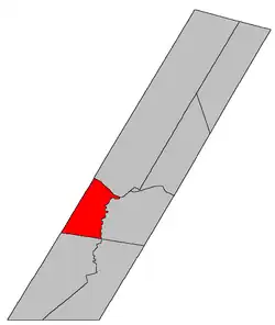
Lincoln | |
|---|---|
 Location within Sunbury County, New Brunswick | |
| Coordinates: 45°53′51″N 66°34′12″W / 45.8975°N 66.57°W | |
| Country | |
| Province | |
| County | Sunbury |
| Erected | 1786 |
| Area | |
| • Land | 159.44 km2 (61.56 sq mi) |
| Population (2021)[1] | |
| • Total | 7,519 |
| • Density | 47.2/km2 (122/sq mi) |
| • Change 2016-2021 | |
| • Dwellings | 3,152 |
| Time zone | UTC-4 (AST) |
| • Summer (DST) | UTC-3 (ADT) |
| Figures do not include portion within the city of Fredericton | |
Lincoln is a civil parish in Sunbury County, New Brunswick, Canada.[2]
Prior to the 2023 governance reform, for governance purposes it was divided between the city of Fredericton and the local service districts of Rusagonis-Waasis and the parish of Lincoln,[3] all of which were members of Regional Service Commission 11 (RSC11).[4]
Origin of name
The parish may have been named for its proximity to York County, as the traditional English counties of Lincolnshire and Yorkshire shared a border.[5]
Another possible source is Lincoln, Massachusetts, former home of Captain Benjamin Glasier whose family settled there in March 1776 as the American War of Independence was beginning.[6]
History
Lincoln was erected in 1786 as one of Sunbury County's original parishes.[7] It extended to Charlotte County and included most of Gladstone Parish.
In 1835 the rear of the parish was included in the newly erected Blissville Parish.[8]
Boundaries
Lincoln Parish is bounded:[2][9][10]
- on the northeast by the Saint John River;
- on the southeast by the Oromocto River;
- on the southwest by a line beginning on the Oromocto River about 1.2 kilometres downstream of the mouth of Shaw Creek and running north 66º west[lower-alpha 1] to the York County line;
- on the northwest by the York County line;
- including Thatch Island in the Saint John River.
Communities
Communities at least partly within the parish.[9][10][14] bold indicates an incorporated municipality
- Fredericton
- Lincoln
- Lower Lincoln
- Nevers Road
- Rusagonis
- Rusagonis Station
- Sunpoke
- Waasis
Bodies of water
Bodies of water[lower-alpha 2] at least partly within the parish.[9][10][14]
- Oromocto River
- Saint John River
- Little Waasis Stream
- Rusagonis Stream
- Waasis Stream
- The Thoroughfare
- Bear Creek
- Deer Creek
- Shaw Creek
- Wilmot Creek
- Sunpoke Lake
Islands
Islands at least partly within the parish.[9][10][14]
- Thatch Island
Other notable places
Parks, historic sites, and other noteworthy places at least partly within the parish.[9][10][14]
- Fredericton International Airport
- Vanier Industrial Park
Demographics
Parish population does not include portion within Fredericton
Population
|
LanguageMother tongue (2016)[17]
|
See also
Notes
References
- 1 2 "Census Profile". Statistics Canada. 26 October 2022. Retrieved 29 October 2022.
- 1 2 3 "Chapter T-3 Territorial Division Act". Government of New Brunswick. Retrieved 13 November 2020.
- ↑ "New Brunswick Regulation 84-168 under the Municipalities Act (O.C. 84-582)". Government of New Brunswick. Retrieved 22 July 2020.
- ↑ "Communities in each of the 12 Regional Service Commissions (RSC) / Les communautés dans chacune des 12 Commissions de services régionaux (CSR)" (PDF), Government of New Brunswick, July 2017, retrieved 2 February 2021
- ↑ Ganong, William F. (1896). A Monograph of the Place-Nomenclature of the Province of New Brunswick. Royal Society of Canada. p. 245. Retrieved 17 March 2021.
- ↑ Ganong, William F. (1906). Additions and Corrections to Monographs on the Place-Nomenclature, Cartography, Historic Sites, Boundaries and Settlement-origins of the Province of New Brunswick. Royal Society of Canada. p. 30. Retrieved 12 April 2021.
- ↑ "26 Geo. III Chapter I. An Act for the better ascertaining and confirming the Boundaries of the several Counties within this Province, and for subdividing them into Towns or Parishes.". Acts of the General Assembly of His Majesty's Province of New-Brunswick, passed in the year 1786. Saint John, New Brunswick: Government of New Brunswick. 1786. pp. 3–12. Retrieved 20 March 2021.
- ↑ "4 Wm. IV c. 42 An Act to erect a new Parish in the County of Sunbury.". Acts of the General Assembly of His Majesty's Province of New Brunswick, Passed in the Year 1834. Fredericton: Government of New Brunswick. 1834. pp. 103–104. Retrieved 27 March 2021.
- 1 2 3 4 5 "No. 126". Provincial Archives of New Brunswick. Department of Natural Resources and Energy Development. Retrieved 22 June 2021. Remainder of parish on maps 127 and 137 at same site.
- 1 2 3 4 5 "371" (PDF). Transportation and Infrastructure. Government of New Brunswick. Retrieved 22 June 2021. Remainder of parish on mapbooks 390, 391, 409, and 410 at same site.
- ↑ "4 Wm. IV c. 42 An Act to erect a new Parish in the County of Sunbury.". Acts of the General Assembly of His Majesty's Province of New Brunswick, Passed in the Year 1834. Fredericton: Government of New Brunswick. 1834. pp. 103–104. Retrieved 27 March 2021.
- ↑ "Historical Magnetic Declination". National Oceanic and Atmospheric Administration. Retrieved 28 April 2021.
- ↑ "Chapter 227 Territorial Division Act". The Revised Statutes of New Brunswick 1952 Volume III. Fredericton: Government of New Brunswick. 1952. pp. 3725–3771.
- 1 2 3 4 "Search the Canadian Geographical Names Database (CGNDB)". Government of Canada. Retrieved 6 July 2021.
- ↑ Statistics Canada: 1996, 2001, 2006 census
- ↑ 2011 Statistics Canada Census Profile: Lincoln Parish, New Brunswick
- 1 2 "Census Profile, 2016 Census: Lincoln, Parish [Census subdivision], New Brunswick". Statistics Canada. Retrieved 1 September 2019.