| Lindlarer Sülz | |
|---|---|
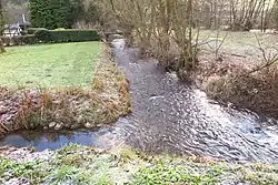
 Lindlarer Sülz near Hartegasse | |
| Location | |
| Country | Germany |
| State | North Rhine-Westphalia |
| Physical characteristics | |
| Source | |
| • location | Near Obersiemeringhausen |
| • coordinates | 51°5′4.9″N 7°30′4.9″E / 51.084694°N 7.501361°E |
| • elevation | 387 m (1,270 ft) |
| Mouth | |
• location | Sülz |
• coordinates | 51°00′27″N 7°16′57″E / 51.0075°N 7.2826°E |
• elevation | 128 m (420 ft) |
| Length | 23.8 km (14.8 mi) |
| Basin features | |
| Progression | Sülz→ Agger→ Sieg→ Rhine→ North Sea |
Lindlarer Sülz is a river of North Rhine-Westphalia, Germany.[1] The Sülz is formed by the confluence of the Kürtener Sülz with the Lindlarer Sülz in Lindlar-Hommerich. .
See also
References
- ↑ "Gewässerverzeichnis des Landesamtes für Natur, Umwelt und Verbraucherschutz NRW 2010" (in German). Landesamt für Natur, Umwelt und Verbraucherschutz NRW. 2010. Retrieved 2017-02-27.
This article is issued from Wikipedia. The text is licensed under Creative Commons - Attribution - Sharealike. Additional terms may apply for the media files.