Lingling
零陵区 | |
|---|---|
 Lingling Pavilion | |
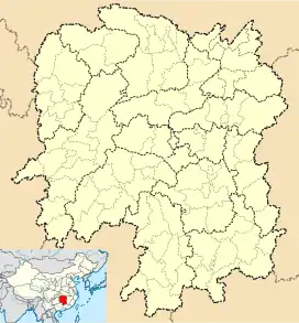
 Lingling Location in Hunan | |
| Coordinates: 26°13′17″N 111°37′01″E / 26.2215°N 111.6169°E[1] | |
| Country | People's Republic of China |
| Province | Hunan |
| Prefecture-level city | Yongzhou |
| District seat | Xujiajing Subdistrict |
| Area | |
| • Total | 1,959.11 km2 (756.42 sq mi) |
| Population (2010)[3] | |
| • Total | 528,637 |
| • Density | 270/km2 (700/sq mi) |
| Time zone | UTC+8 (China Standard) |
| Postal code | 425XXX |
| Area code | 0746 |
| Official Language | Standard Chinese |
| Dialects | Yongzhou dialect |
| Website | www |
| Lingling, Yongzhou | |||||||
|---|---|---|---|---|---|---|---|
| Traditional Chinese | 零陵區 | ||||||
| Simplified Chinese | 零陵区 | ||||||
| |||||||
Lingling District is one of two urban districts of Yongzhou City, Hunan Province, China. It is located on the south of the city proper, and lies to the eastern border of Guangxi.

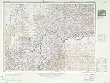
Map including Lingling (labeled as LING-LING (YUNGCHOW) 零陵) (AMS, 1954)
The district is bordered to the north by Dong'an County and Lengshuitan District, to the east by Qiyang County, to the south by Shuangpai County, to the west by Quanzhou County of Guangxi. Lingling District covers 1,962 km2 (758 sq mi), as of 2015, It had a registered population of 622,400.[4] Lingling District has four subdistricts, 7 towns and 3 townships under its jurisdiction, the government seat is Xujiajing (徐家井街道).[5]
Administrative divisions
- 4 subdistricts
- Chaoyang (朝阳街道)
- Nanjindu (南津渡街道)
- Qilidian (七里店街道)
- Xujiajing (徐家井街道)
- 7 towns
- Fujiaqiao (富家桥镇)
- Huangtianpu (黄田铺镇)
- Lingjiaotang (菱角塘镇)
- Shiyantou (石岩头镇)
- Shuikoushan (水口山镇)
- Youtingxu (邮亭墟镇)
- Zhushan (珠山镇)
- 3 townships
- Dangdi (凼底乡)
- Daqingping (大庆坪乡)
- Shuzipu (梳子铺乡)
Climate
| Climate data for Lingling (1991–2010 normals, extremes 1981–2010) | |||||||||||||
|---|---|---|---|---|---|---|---|---|---|---|---|---|---|
| Month | Jan | Feb | Mar | Apr | May | Jun | Jul | Aug | Sep | Oct | Nov | Dec | Year |
| Record high °C (°F) | 25.9 (78.6) |
31.6 (88.9) |
35.7 (96.3) |
35.7 (96.3) |
35.2 (95.4) |
38.0 (100.4) |
39.7 (103.5) |
40.3 (104.5) |
38.1 (100.6) |
36.2 (97.2) |
33.7 (92.7) |
26.3 (79.3) |
40.3 (104.5) |
| Mean daily maximum °C (°F) | 9.4 (48.9) |
12.4 (54.3) |
16.4 (61.5) |
23.1 (73.6) |
27.4 (81.3) |
30.4 (86.7) |
33.5 (92.3) |
32.8 (91.0) |
29.1 (84.4) |
23.9 (75.0) |
18.3 (64.9) |
12.2 (54.0) |
22.4 (72.3) |
| Daily mean °C (°F) | 6.4 (43.5) |
8.9 (48.0) |
12.6 (54.7) |
18.7 (65.7) |
23.0 (73.4) |
26.3 (79.3) |
29.0 (84.2) |
28.1 (82.6) |
24.6 (76.3) |
19.5 (67.1) |
14.1 (57.4) |
8.6 (47.5) |
18.3 (65.0) |
| Mean daily minimum °C (°F) | 4.2 (39.6) |
6.4 (43.5) |
10.0 (50.0) |
15.5 (59.9) |
19.8 (67.6) |
23.5 (74.3) |
25.7 (78.3) |
24.8 (76.6) |
21.4 (70.5) |
16.3 (61.3) |
11.0 (51.8) |
5.9 (42.6) |
15.4 (59.7) |
| Record low °C (°F) | −3.9 (25.0) |
−4.6 (23.7) |
0.0 (32.0) |
4.1 (39.4) |
9.3 (48.7) |
14.5 (58.1) |
18.7 (65.7) |
18.4 (65.1) |
13.0 (55.4) |
4.7 (40.5) |
−0.6 (30.9) |
−5.2 (22.6) |
−5.2 (22.6) |
| Average precipitation mm (inches) | 84.6 (3.33) |
94.3 (3.71) |
168.1 (6.62) |
164.8 (6.49) |
213.2 (8.39) |
186.8 (7.35) |
128.5 (5.06) |
154.3 (6.07) |
54.5 (2.15) |
66.3 (2.61) |
83.8 (3.30) |
60.6 (2.39) |
1,459.8 (57.47) |
| Average precipitation days (≥ 0.1 mm) | 15.1 | 14.8 | 19.3 | 16.8 | 16.2 | 15.2 | 10.4 | 12.0 | 9.2 | 9.5 | 10.5 | 11.3 | 160.3 |
| Average snowy days | 3.1 | 1.5 | 0.3 | 0 | 0 | 0 | 0 | 0 | 0 | 0 | 0 | 0.9 | 5.8 |
| Average relative humidity (%) | 79 | 79 | 82 | 79 | 79 | 80 | 72 | 75 | 76 | 75 | 75 | 74 | 77 |
| Mean monthly sunshine hours | 54.2 | 53.4 | 62.7 | 94.3 | 127.0 | 134.7 | 220.9 | 191.7 | 145.1 | 123.6 | 108.6 | 90.8 | 1,407 |
| Percent possible sunshine | 16 | 17 | 17 | 25 | 30 | 33 | 53 | 48 | 40 | 35 | 34 | 28 | 31 |
| Source: China Meteorological Administration[6][7] | |||||||||||||
Education
Secondary school
Universities and Colleges
Notable people
- Li Da - Chinese Marxist philosopher and President of Wuhan University (1952-1966)
- Huaisu - Buddhist monk and calligrapher of the Tang dynasty
- Huang Gai - military general during the late Eastern Han dynasty of China
- Liu Wen - China's first supermodel[8]
References
- www.xzqh.org (in Chinese)
- ↑ Google (2014-07-02). "Xujiajing Sub-district Office" (Map). Google Maps. Google. Retrieved 2014-07-02.
- ↑ Yongzhou City Land Use Plan (2006–20)/《永州市土地利用总体规划(2006-2020年)》.(in Chinese) Accessed 8 July 2014.
- ↑ "永州市2010年第六次全国人口普查主要数据公报". TJCN.org (in Chinese). China Statistical Information Network/中国统计信息网. Archived from the original on 17 September 2014. Retrieved 9 July 2014.
- ↑ the population of Lingling District in 2015, according to the 2015年零陵区国民经济和社会发展统计公报 [Statistical Communiqué of Lingling District on the 2015 National Economic and Social Development]. Yongzhou People's Government. or yztj.gov.cn
- ↑ 《湖南省民政厅关于同意零陵区乡镇区划调整方案的批复》(湘民行发〔2015〕28号 [result on adjustment of township-level administrative divisions of Lingling District on 18 November 2015]. rednet.cn Hunan. 2015-12-04., yzcity.gov.cn or yzfgw.gov.cn, also see 《湖南省乡镇区划调整改革109个县市区批复方案》. people.com Hunan. 2015-12-08. or xinhuanet.com. Also see the full version of adjustment of village-level divisions: yz.rednet.cn
- ↑ 中国气象数据网 – WeatherBk Data (in Simplified Chinese). China Meteorological Administration. Retrieved 23 September 2023.
- ↑ 中国气象数据网 (in Simplified Chinese). China Meteorological Administration. Retrieved 23 September 2023.
- ↑ Parker, Nick (2011-09-30). "How a small-town girl became China's first supermodel". CNN. Retrieved 2023-11-08.
External links
This article is issued from Wikipedia. The text is licensed under Creative Commons - Attribution - Sharealike. Additional terms may apply for the media files.