Lisbon, Maryland | |
|---|---|
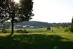
 Dairy farm near Lisbon | |
 Lisbon  Lisbon | |
| Coordinates: 39°20′13″N 77°04′25″W / 39.33694°N 77.07361°W | |
| Country | |
| State | |
| County | Howard |
| Area | |
| • Total | 1.48 sq mi (3.83 km2) |
| • Land | 1.48 sq mi (3.82 km2) |
| • Water | 0.00 sq mi (0.01 km2) |
| Elevation | 577 ft (176 m) |
| Population (2020) | |
| • Total | 282 |
| • Density | 191.06/sq mi (73.78/km2) |
| Time zone | UTC-5 (Eastern (EST)) |
| • Summer (DST) | UTC-4 (EDT) |
| FIPS code | 24-47250 |
| GNIS feature ID | 2806300[2] |
Lisbon is a census-designated place located in western Howard County in the state of Maryland, United States, located roughly between Baltimore and Frederick and north of Washington, D.C.[3] It is contained in an area of roughly one square mile. Lisbon is located along Interstate 70 and Maryland Route 144 and is home to the first roundabout in Maryland (opened in 1993).[4][5] It first appeared as a CDP in the 2020 Census with a population of 282.[6]
History

Lisbon is situated on a land grant patented by Seth Warfield in 1794 as "Warfield's Forest". The town was founded by Caleb Pancoast in 1810.[7] Named "New Lisbon", followed by a shortened "Lisbon" name (not Portugal's capital).[8] In 1820, Pancoast deeded land for the Union Church for Public Worship which would become a schoolhouse with gravesites remaining in 1880. Pancoast subdivided the town in 1822 with one hundred lots of a quarter acre in size, including roads and alleys. By 1835, eight scheduled daily stagecoaches ran through town.[9] The town built the single room Annapolis Rock School in 1894, which served the area until 1943.[10]
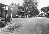
The photograph is the National Road (now MD 144), looking east toward Baltimore. The road between the two houses is Madison Street.[11] Through the center of town, Woodbine Road runs north for 2 miles (3.2 km) to Woodbine, where the Patapsco River and the B&O Railroad cross the road. About one mile north of Lisbon exists the original road that ran from Baltimore to Frederick. This road runs west toward Poplar Springs and east toward Sykesville. The exact route of this road is not discernible at this time.
Lisbon is home to the Carr's Mill Landfill, the county's second landfill, which closed in 1977 and was the site of toxic dumping.[12]
Lisbon changed from an unincorporated community to a census-designated place for the 2020 census.[13]
Demographics
| Census | Pop. | Note | %± |
|---|---|---|---|
| 2020 | 282 | — | |
| U.S. Decennial Census[14] 2020[15] | |||
2020 census
| Race / Ethnicity | Pop 2020[15] | % 2020 |
|---|---|---|
| White alone (NH) | 232 | 82.27% |
| Black or African American alone (NH) | 3 | 1.06% |
| Native American or Alaska Native alone (NH) | 1 | 0.35% |
| Asian alone (NH) | 24 | 8.51% |
| Pacific Islander alone (NH) | 0 | 0.00% |
| Some Other Race alone (NH) | 2 | 0.71% |
| Mixed Race/Multi-Racial (NH) | 17 | 6.03% |
| Hispanic or Latino (any race) | 3 | 1.06% |
| Total | 282 | 100.00% |
Note: the US Census treats Hispanic/Latino as an ethnic category. This table excludes Latinos from the racial categories and assigns them to a separate category. Hispanics/Latinos can be of any race.
References
- ↑ "2020 U.S. Gazetteer Files". United States Census Bureau. Retrieved April 26, 2022.
- 1 2 U.S. Geological Survey Geographic Names Information System: Lisbon, Maryland
- ↑ Gannett, Henry (1904). A Gazetteer Of Maryland (PDF). Washington, D.C.: Government Printing Office. p. 48. Retrieved August 27, 2022.
- ↑ "Roundabout Safety Comes to America pg 1, Autumn 1995, Public Roads". Archived from the original on May 10, 2009. Retrieved September 7, 2009.
- ↑ "Traveling Maryland's Roundabouts - History". www.sha.state.md.us. Archived from the original on July 24, 2011. Retrieved January 17, 2022.
- ↑ "Lisbon CDP, Maryland". United States Census Bureau. Retrieved March 13, 2022.
- ↑ Seeking Freedom The History of the Underground Railroad in Howard County. p. 78.
- ↑ The Howard County Historical Society (August 22, 2011). Howard County (Images of America). Charleston, S.C.: Arcadia Publishing. p. 42. ISBN 978-0738587660.
- ↑ Feaga, Barbara. Howard's Roads to the Past. p. 44.
- ↑ The Howard County Historical Society (August 22, 2011). Howard County (Images of America). Charleston, S.C.: Arcadia Publishing. p. 65. ISBN 978-0738587660.
- ↑ Google (June 1, 2019). "Lisbon, Maryland" (Map). Google Maps. Google. Retrieved June 1, 2019.
- ↑ Timberg, Craig (February 6, 1997). "$2.85 million deal reached on Carrs Mill 3 national companies paying for cleanup at toxic landfill; 'A very fair settlement'; None of the firms is admitting liability". The Baltimore Sun. Archived from the original on June 22, 2021.
- ↑ "TIGERweb v18.0". Decennial IT Division for Geography Division, U.S. Census Bureau. Retrieved February 26, 2021.
- ↑ "Decennial Census of Population and Housing by Decades". US Census Bureau.
- 1 2 "P2 HISPANIC OR LATINO, AND NOT HISPANIC OR LATINO BY RACE - 2020: DEC Redistricting Data (PL 94-171) - Lisbon CDP, Maryland". United States Census Bureau.
External links
