This is a list of lighthouses in Mauritius.[1][2]
Lighthouses
| Name | Image | Year built | Location & coordinates | Class of Light[2] | Focal height[2] | NGA number[2] | Admiralty number[2] | Range nml[2] |
|---|---|---|---|---|---|---|---|---|
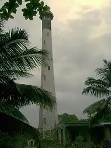
| Pointe aux Caves Lighthouse | .jpg.webp) | 1910 | 20°11′28.3″S 57°24′41.5″E / 20.191194°S 57.411528°E | Fl (2) W 10s. | 46 metres (151 ft) | 32852 | D7096 | 29 |
| Pointe aux Sables Lighthouse | n/a | 20°10′04.0″S 57°28′19.0″E / 20.167778°S 57.471944°E | Al Iso WG 4s. | 24 metres (79 ft) | 32872 | D7097 | 10 | |
| Port Louis Range Front Lighthouse | n/a | 20°09′28.0″S 57°29′54.6″E / 20.157778°S 57.498500°E | Oc R 10s. | 39 metres (128 ft) | 32861 | D7101 | 13 | |
| Port Louis Range Rear Lighthouse | n/a | 20°09′43.0″S 57°30′13.8″E / 20.161944°S 57.503833°E | F or Fl WRG as direction | 69 metres (226 ft) | 32861.5 | D7101.1 | 17 | |
| Île Plate Lighthouse | 1855 | 19°52′54.4″S 57°39′00.2″E / 19.881778°S 57.650056°E | Fl (4) W30s. | 111 metres (364 ft) | 32848 | D7096 | 29 | |
In 1995, the lighthouses of Mauritius were commemorated in 4 stamps.[3]
See also
References
- ↑ Rowlett, Russ. "Lighthouses of Mauritius". The Lighthouse Directory. University of North Carolina at Chapel Hill. Retrieved 2016-09-20.
- 1 2 3 4 5 6 List of Lights, Pub. 112: Western Pacific and Indian Oceans Including the Persian Gulf and Red Sea (PDF). List of Lights. United States National Geospatial-Intelligence Agency. 2016. Retrieved 22 September 2016
- ↑ "Stamp: Pointe aux Caves (Mauritius 1995)". touchstamps.com. Retrieved 2021-06-13.
External links
Rowlett, Russ. "The Lighthouse Directory". University of North Carolina at Chapel Hill.
| Types |
| _-_cropped.jpg.webp) | ||||
|---|---|---|---|---|---|---|
| Fixtures | ||||||
| Maintenance | ||||||
| Locations | ||||||
| Categories |
| |||||
| Global organizations | ||||||
| ||||||
Lists of lighthouses in Africa | ||||||
|---|---|---|---|---|---|---|
| Sovereign states |
|  | ||||
This article is issued from Wikipedia. The text is licensed under Creative Commons - Attribution - Sharealike. Additional terms may apply for the media files.