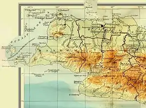
Old map of Banten with major rivers.
This is a list of rivers flowing in the province of Banten, Indonesia.[1][2]
In alphabetical order
Watershed area
In Banten Province there are four river regions (Indonesian: Wilayah Sungai); two of them are under the authority of Banten Province, i.e. Ciliman-Cibungur and Cibaliung-Cisawarna, whereas the other two are under the authority of the central government, i.e. Cidanau-Ciujung-Cidurian and Ciliwung-Cisadane.[3]
The government of Banten Province has the authority over 102 watershed areas (Indonesian: Daerah Aliran Sungai), including 75 areas in the Cibaliung Cisawarna river region and 27 other in Ciliman Cibungur river region.[4]
The watershed areas and the river regions in Banten Province are as follows:
- 1. Cibaliung Cisawarna River Region (under Banten Province)
- 2. Ciliman Cibungur River Region (under Banten Province)
- 3. Cidanau Ciujung Cidurian River Region (under the central government)
- 4. Ciliwung Cisadane River Region (under the central government)
See also
- Drainage basins of Java
- List of drainage basins of Indonesia
References
- ↑ Map of Java. Peta Pulau Jawa. El Sena, Surabaya. Accessed 1 July 2017.
- ↑ Map of Indonesia. Peta Indonesia. Wawasan Nusantara. CV. Indo Prima Sarana. Accessed 29 Juli 2017.
- ↑ Daerah Aliran Sungai (DAS) dan Wilayah Sungai (WS)di Provinsi Banten. Oleh:R.D Ambarwati, ST.MT. Provinsi Banten. Diakses 5 Februari 2018.
- ↑ Berdasarkan Peraturan Menteri Pekerjaan Umum dan Perumahan Rakyat Nomor 4/PRT/M/2015 tentang Kriteria dan Penetapan Wilayah Sungai.
This article is issued from Wikipedia. The text is licensed under Creative Commons - Attribution - Sharealike. Additional terms may apply for the media files.