| Lisa | |
|---|---|
 Llisa is visible in the lower right part of this satellite image (center, right). Sajama volcano is shown in the lower center. | |
| Highest point | |
| Elevation | 4,708 m (15,446 ft)[1] |
| Coordinates | 17°58′55″S 68°46′07″W / 17.98194°S 68.76861°W |
| Geography | |
 Lisa Location within Bolivia | |
| Location | Bolivia, Oruro Department, Sajama Province |
| Parent range | Andes |
Llisa (Aymara for a variety of quartz, also for a stone with a special shape used to shear llamas)[2] is a 4,708-metre-high (15,446 ft) mountain in the Andes of Bolivia. It is located in the Oruro Department, Sajama Province, Curahuara de Carangas Municipality. Llisa lies northeast of the Sajama volcano.[1][3]
References
- 1 2 Bolivian IGM map 1:50,000 Okoruro 5840-III
- ↑ "Diccionario Bilingüe, Castellano - Aymara, Para: Tercera Edición". Félix Layme Pairumani. Archived from the original on March 4, 2016. Retrieved December 7, 2014. see: Pedernal
- ↑ "Curahuara de Carangas". INE, Bolivia. Archived from the original on November 8, 2014. Retrieved December 7, 2014.
Capital: Oruro | ||
| Provinces | 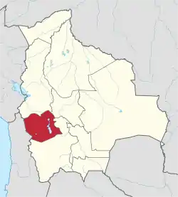 | |
| Municipalities (and seats) |
| |
This article is issued from Wikipedia. The text is licensed under Creative Commons - Attribution - Sharealike. Additional terms may apply for the media files.