| Lliwedd Bach | |
|---|---|
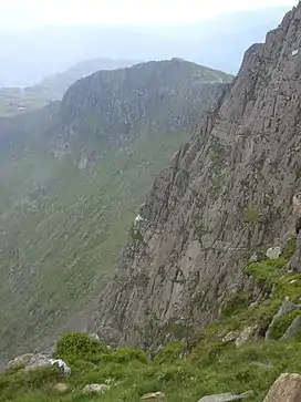 Lliwedd Bach from near Y Lliwedd | |
| Highest point | |
| Elevation | 818 m (2,684 ft) |
| Prominence | 16 m (52 ft) |
| Parent peak | Y Lliwedd |
| Listing | Nuttall |
| Coordinates | 53°03′32″N 4°02′56″W / 53.0589°N 4.0490°W |
| Naming | |
| English translation | small colourless peak |
| Language of name | Welsh |
| Pronunciation | Welsh: [ˈɬɪwɛð bax] |
| Geography | |
| Location | Gwynedd, Wales |
| Parent range | Snowdonia |
| OS grid | SH622533 |
| Topo map | OS Landranger 115 |
Lliwedd Bach is a top of Y Lliwedd in the Snowdonia National Park, North Wales. It is the last "top" on the main ridge of Y Lliwedd, the other being Y Lliwedd East Peak. A broad ridge at around 580m carries on northwards until the subsidiary summit of Gallt y Wenallt is reached.
The summit is unmarked and offers good views of Y Lliwedd's cliffs, Snowdon (Yr Wyddfa) and Crib Goch.[1]
References
External links
This article is issued from Wikipedia. The text is licensed under Creative Commons - Attribution - Sharealike. Additional terms may apply for the media files.