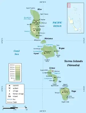
Native name: Lō | |
|---|---|
 Location of Lo in the Torres Islands of Vanuatu | |
| Geography | |
| Location | Pacific Ocean |
| Archipelago | Vanuatu, Torres Islands |
| Area | 11.9 km2 (4.6 sq mi) |
| Highest elevation | 155 m (509 ft) |
| Administration | |
Vanuatu | |
| Province | Torba Province |
| Demographics | |
| Population | 210 (2009) |
Lo [lo] (sometimes wrongly spelled Loh) is an island in the Torres group of islands, in northern Vanuatu. The island is located 2.25 miles from the Toga Island.[1] As of 2009, the population of the island was 210.[2] They speak the Lo dialect of the Lo-Toga language.
Name
The name Lo comes from the Lo-Toga language, where it is spelt Lō [lo]. It is of obscure origin.
Transportation
The Torres islands are served by Torres Airport, which is located on the Linua island, just off the north coast of Lo. The airport is mostly used by Lo residents. Lo is not frequently visited by outsiders.
.jpg.webp)
Villages
Lo has two main villages: Lun̄haregi [lʉŋˈharəɣi] (a.k.a. Lunghariki) and Rinuhe [riˈnʉhə]; and a smaller hamlet, Telaqlaq [təlakʷˈlakʷ]. In 2018, the Vanuatu Coastal Adaptation Project provided the villages with access to fresh water.[3]
References
- ↑ Sailing Directions (enroute) for the Pacific Islands. Defense Mapping Agency, Hydrographic/Topographic Center. 2002. p. 177.
- ↑ "2009 National Census of Population and Housing: Summary Release" (PDF). Vanuatu National Statistics Office. 2009. Retrieved October 11, 2010.
- ↑ Roberts, Compiled by Anita. "Bringing clean water to Loh, Toga Islands". Vanuatu Daily Post. Retrieved 2020-04-02.
13°20′24″S 166°37′48″E / 13.34000°S 166.63000°E
