Lollar | |
|---|---|
 | |
 Coat of arms | |
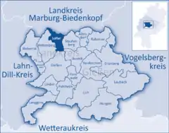
Location of Lollar within Gießen district  | |
 Lollar  Lollar | |
| Coordinates: 50°38′59″N 08°42′16″E / 50.64972°N 8.70444°E | |
| Country | Germany |
| State | Hesse |
| Admin. region | Gießen |
| District | Gießen |
| Government | |
| • Mayor (2022–28) | Jan-Erik Dort[1] (Ind.) |
| Area | |
| • Total | 21.90 km2 (8.46 sq mi) |
| Elevation | 173 m (568 ft) |
| Population (2022-12-31)[2] | |
| • Total | 10,454 |
| • Density | 480/km2 (1,200/sq mi) |
| Time zone | UTC+01:00 (CET) |
| • Summer (DST) | UTC+02:00 (CEST) |
| Postal codes | 35457 |
| Dialling codes | 06406 |
| Vehicle registration | GI |
| Website | www.lollar.de |
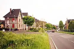
Lollar is a town in the district of Gießen, in Hesse, in west-central Germany. It is situated on the river Lahn, 7 km north of Gießen. The biggest production site of Bosch Thermotechnology is located in Lollar.
During World War II, in February 1945, the Germans established a Dulag transit camp for British and Commonwealth prisoners of war in the town, which was liberated by American troops on March 28, 1945.[3]
References
- ↑ "Ergebnisse der jeweils letzten Direktwahl von Landrätinnen und Landräte sowie (Ober-)Bürgermeisterinnen und (Ober-)Bürgermeister in Hessen, Stand 13.04.2023" (XLS) (in German). Hessisches Statistisches Landesamt.
- ↑ "Bevölkerung in Hessen am 31.12.2022 nach Gemeinden" (XLS) (in German). Hessisches Statistisches Landesamt. June 2023.
- ↑ Megargee, Geoffrey P.; Overmans, Rüdiger; Vogt, Wolfgang (2022). The United States Holocaust Memorial Museum Encyclopedia of Camps and Ghettos 1933–1945. Volume IV. Indiana University Press, United States Holocaust Memorial Museum. p. 525. ISBN 978-0-253-06089-1.
This article is issued from Wikipedia. The text is licensed under Creative Commons - Attribution - Sharealike. Additional terms may apply for the media files.