Longido District
Wilaya ya Longido (Swahili) | |
|---|---|
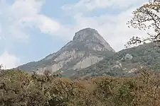
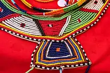
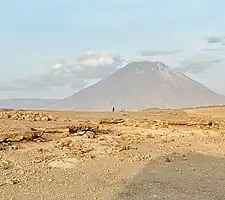
   From top to bottom: Mount Londido, Longido District and Maasai beads and Ol Doinyo Lengai view from Longido District | |
| Nickname: The gem district | |
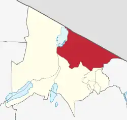
 Longido District in Arusha | |
| Coordinates: 02°37′2.64″S 36°26′11.04″E / 2.6174000°S 36.4364000°E | |
| Country | |
| Region | Arusha Region |
| District | 1 July 2007 [1] |
| Named for | Mount Longido |
| Capital | Longido |
| Area | |
| • Total | 7,885 km2 (3,044 sq mi) |
| • Rank | 2nd in Arusha |
| Elevation | 1,387 m (4,551 ft) |
| Highest elevation (Gelai) | 2,942 m (9,652 ft) |
| Population (2012) | |
| • Total | 123,153 |
| • Rank | 7th in Arusha |
| • Density | 16/km2 (40/sq mi) |
| Demonym | Longidan |
| Ethnic groups | |
| • Settler | Maasai & Swahili |
| • Native | Rwa & Sonjo |
| Time zone | UTC+3 (EAT) |
| Tanzanian Postcode | 235xx |
| Website | Official website |
| Symbols of Tanzania | |
| Bird | |
| Mammal | |
Longido District (Wilaya ya Longido in Swahili) is one of seven districts of the Arusha Region of Tanzania. The district is bordered to the east by the Ngorongoro District, to the south west by the Monduli District and southeast by the Arusha Rural District and Meru District. To the far east by Siha District of Kilimanjaro Region and the north by Kenya. It covers an area of 7,885 km2 (3,044 sq mi).[2] The district is comparable in size to the land area of Puerto Rico.[3]Longido District was created in 2007 from Monduli District. Mount Longido, Gelai and Kitumbeine volcano are all located within the boundaries of the district. The administrative seat is the town of Longido. According to the 2012 census, the population of the district was 123,153.[4] Longido District is known as Arusha's gem district as its home to Anyolite and Rubies.
Geography
The District has an area of 7,782 square kilometers, of which 9.4% is arable land, equivalent to 73,164 hectares, and the remaining 82.14% is grazing land, equivalent to 639,235 hectares. In addition, woodland and rock cover 365.75 square kilometers of land, or 36575 hectares, or 4.7%.[5]
Climate
The district is one of Tanzania's driest areas, with temperatures ranging from 20°C to 35°C with rainfall ranging from less than 500mm in the lowlands to 900mm in the high elevations of West Kilimanjaro, Ketumbeine, and Gelai mountains. It is Arusha's driest district. [6]
Topography
The District has three types of soil: shallow soils that are poor and unsuitable for agriculture, deep freely drained soils that are rich in natural fertilizers but have a low infiltration rate, and deep freely drained soils that are appropriate for agricultural cultivation. [7] Ketumbeine, Gelai, and Oldonyo Lengai Mountains are among the solitary mountains located in Longido District. The elevation ranges from 600m to 2,900m above sea level. The vegetation is diverse, including a mixed forest, bush regions, and grassland.[8]
Economy
TZS 14,787,392,620/= was calculated as the district's income (for the year 2002). According to these statistics, the annual per capita income for Longido District Council residents was around Tshs.199,630/=, compared to the Regional Tshs.286,000/=. The agriculture sector contributes about 5% of the district's income. Other sectors that contribute to district income include cattle, business, tourism, and minor industries, which account for 95% of district income. In terms of per capita income of the habitation every year, it is clear that poverty remains a problem for the inhabitants of Longido District Council.[9]
Infrastructure
Almost all District water supply statistics show an alarming lack of water for both human and livestock use. The main causes of insufficient water supply, particularly in rural regions, are a lack of natural water sources such as springs and a lack of perennial rivers. [10] Currently, 42% of Longido District Council residents have access to safe and clean drinking water from upgraded sources such as springs, bore holes, rain water, streams, rivers, and shallow wells.
The District road network has a total length of 563.9 kilometers, of which 229 kilometers are District roads, 355.9 kilometers are feeder roads, 36 kilometers are Urban roads, and 244 kilometers are under TANROAD. About 15.5% of road networks are in good shape, 45.4% are in medium shape, and 35.9% are in poor shape. 81.3% of the route is open all year, while 18.7% is closed during the rainy season. [11] Paved trunk road T2 from Arusha to the Kenyan border town Namanga passes through the district.[12]
Agriculture
Agriculture is the major economic activity of people in Longido District council. The land currently under cultivation is 29,223 Hectares or 3.76% of the total arable land which is 36,578 Hectares. About 6,158 of the population are engaged fully in agriculture which is 5% of the population, growing cash crops mainly wheat in the highlands. Food crops grown in the District include Horticultural crops, maize, beans, green beans and potatoes in the highlands and the rest in the lowlands of the district. [13]
The District contains 117,000 livestock producers who own a range of livestock, including 234 dairy cattle, 356,430 beef cattle, 192,970 sheep, 455 pigs, 329,673 goats, and 11,123 donkeys.In the highlands, livestock are kept on a semi-intensive grazing system, whereas in the lowlands, most animals are grazed on communal land. The District currently has 24 cattle dips, 5 livestock development centers, 6 bulls centers, 2 slaughter houses, 14 slaughter slabs, 2 milk collection canters, and 14 livestock input outlets.[14]
Tourism
There are attractive areas in terms of photographic tourism, hunting blocks, cultural tourism, campsites along the famous Lake Natron, home to millions of flamingo and viewing of Oldonyolengai nature of active volcano eruptions, campsites within the species on the flat lands bounded by famous mountain of Kilimanjaro, Meru, Longido, Namanga (Kenyan Mountain), Gelai and Ketumbeine.[15]
The District's projected forest area was 10,780 Hectares, or 13.7 percent of the total land area of 78,820 Hectares. Tanzania's wildlife is an important resource because it is the country's main tourist attraction and a major source of foreign exchange revenues. Approximately 95% of the District is a game-controlled region, making it a popular tourist destination. Tourists come for sport and trophy hunting in the District's four hunting blocks. There are over 40 kinds of fauna and a wide range of bird life, including migratory flamingos, which have their unique breeding place at Lake Natron. The number of wildlife animals in Longido District is estimated to be 100,000 (Ecosystem survey 1980), with a population density of 6.7 per square km (1984).[16]
Mining
The District is primarily endowed with a variety of minerals, however the most minerals extracted are: ruby mining, soda ash extraction, limestone, and sand.[17]
_(Neoproterozoic%253B_Mundarara_Mine%252C_about_27_km_west_of_Longido%252C_Tanzania)_1_(15098298782).jpg.webp)
Demographics
The Maasai are currently the dominant group in the district, whom have migrated to the district from Kenya in the 18th and 19th century.[18] The original inhabitants of the district were the Rwa, Chagga & Sonjo. According to the 2012 National Population Census, the District had a total population of 123,153 people, of which 62,954 were females and 60,199 were males, with an annual growth rate of 3.8 when compared to the 2002 National Population Census, which counted a total of 74,074 people, of which 37,999 were females and 36,075 were males.[19]
Administrative subdivisions
The District is organized administratively into four Divisions (Longido, Ketumbeine, Engarenaibor, and Enduiment), 16 Wards, and 41 Villages.[20]
Constituencies
For parliamentary elections, Arusha Region is divided into constituencies. As of the 2010 elections Longido District had one constituency, Longido Constituency.
Wards
The Longido District is administratively divided into sixteen wards:[21]
Health and Education
Education
Longido District Council operates 45 elementary schools and 216 classrooms. The pupil-to-room ratio is 1:89, compared to a national norm of 1:40. As a result, the District has a shortage of 212 classrooms. Furthermore, there are 4584 desks, resulting in a desk-to-student ratio of 1:4 rather than 1:2 nationally. The student pit latrine ratio for boys is 1:25 and for girls it is 1:20. The District's total pit latrine need is 416 for boys and 443 for girls, yet there are only 156 pit latrines for boys and 159 for girls. There are 19,260 students, with 10,402 boys and 8,858 girls. Enrollment in Standard 7 has grown from 1,852 last year.[22]
Longido District Council has a total of eight secondary schools, with seven government institutions and one private school, totaling 64 classrooms (Government schools). The pupil-to-classroom ratio is 1:71, compared to 1:40 nationally. As a result, the District has a shortage of 60 classrooms. Secondary enrollment went from 3,566 in 2010 to 4,758 in 2011, while those qualifying for further education increased from 196 in 2010 to 2014 in 2011. The increase in the number of students qualifying for high school was owing to an increase in the number of secondary schools, increasing community education awareness, and support from numerous stakeholders.[23]
There are 183 teachers, 64 with a diploma and 119 with a bachelor's degree. The current teacher-to-student ratio is 1:39. The student-to-book ratio is 1:4. School dropout remains an issue; the main causes are truancy, pregnancy, long commutes to school, early marriage, and a negative attitude toward formal education within the Maasai community there.[24]
Healthcare
There are two Government health clinics, one FBO health facility, 22 Government dispensaries, and three FBO dispensaries in the District Council. The district does not have a district hospital; additionally, the required health centers are 16, but there are only three; and the required dispensaries are 41, but there are only 25 including FBO dispensaries.[25]
There are 123 health personnel available out of a total of 292 required. Due to the lack of a District hospital, there are no specialist doctors; there is one Medical Doctor out of four required, one of whom should be a District Medical Officer; three Assistant Medical Doctors are required; and sixteen Clinical Officers are required. Out of the 72 required nurses, 42 are registered and enrolled.[26]
ARI, Pneumonia, Malaria, intestinal worms, minor surgical condition, Diarrhoea, eye disorders, skin illnesses, ear conditions, and UTI are the top ten ailments for children aged five and up. PID and neurosis are also among the top ten to five.[27]
References
- ↑ "Longido District Profile" (PDF). Retrieved 2023-02-12.
- ↑ "Tanzania: Northern Zone(Districts and Wards) - Population Statistics, Charts and Map".
- ↑ 8,870 km2 (3,420 sq mi) for Puerto Rico at "Area size comparison". Nation master. 2022. Retrieved 12 February 2023.
- ↑ "2012 Population and Housing Census" (PDF). Development Partners Group Tanzania. Retrieved 7 August 2019.
- ↑ "Longido District Council Strategic plan 2013" (PDF). Office of the District Executive Director, Longido District. 2013. Retrieved 2023-02-12.
- ↑ "Longido District Council Strategic plan 2013" (PDF). Office of the District Executive Director, Longido District. 2013. Retrieved 2023-02-12.
- ↑ "Longido District Council Strategic plan 2013" (PDF). Office of the District Executive Director, Longido District. 2013. Retrieved 2023-02-12.
- ↑ "Longido District Council Strategic plan 2013" (PDF). Office of the District Executive Director, Longido District. 2013. Retrieved 2023-02-12.
- ↑ "Longido District Council Strategic plan 2013" (PDF). Office of the District Executive Director, Longido District. 2013. Retrieved 2023-02-12.
- ↑ "Longido District Council Strategic plan 2013" (PDF). Office of the District Executive Director, Longido District. 2013. Retrieved 2023-02-12.
- ↑ "Longido District Council Strategic plan 2013" (PDF). Office of the District Executive Director, Longido District. 2013. Retrieved 2023-02-12.
- ↑ "Longido District Council Strategic plan 2013" (PDF). Office of the District Executive Director, Longido District. 2013. Retrieved 2023-02-12.
- ↑ "Longido District Council Strategic plan 2013" (PDF). Office of the District Executive Director, Longido District. 2013. Retrieved 2023-02-12.
- ↑ "Longido District Council Strategic plan 2013" (PDF). Office of the District Executive Director, Longido District. 2013. Retrieved 2023-02-12.
- ↑ "Longido District Council Strategic plan 2013" (PDF). Office of the District Executive Director, Longido District. 2013. Retrieved 2023-02-12.
- ↑ "Longido District Council Strategic plan 2013" (PDF). Office of the District Executive Director, Longido District. 2013. Retrieved 2023-02-12.
- ↑ "Longido District Council Strategic plan 2013" (PDF). Office of the District Executive Director, Longido District. 2013. Retrieved 2023-02-12.
- ↑ Waller, Richard. “The Maasai and the British 1895–1905 the Origins of an Alliance.” The Journal of African History, vol. 17, no. 4, 1976, pp. 529–553., doi:10.1017/S002185370001505X.
- ↑ "Longido District Council Strategic plan 2013" (PDF). Office of the District Executive Director, Longido District. 2013. Retrieved 2023-02-12.
- ↑ "Longido District Council Strategic plan 2013" (PDF). Office of the District Executive Director, Longido District. 2013. Retrieved 2023-02-12.
- ↑ "Postcodes Arusha Region 23000" (PDF). 2012. Archived from the original (PDF) on 2012-09-01. Retrieved 2012-09-01.
- ↑ "Longido District Council Strategic plan 2013" (PDF). Office of the District Executive Director, Longido District. 2013. Retrieved 2023-02-12.
- ↑ "Longido District Council Strategic plan 2013" (PDF). Office of the District Executive Director, Longido District. 2013. Retrieved 2023-02-12.
- ↑ "Longido District Council Strategic plan 2013" (PDF). Office of the District Executive Director, Longido District. 2013. Retrieved 2023-02-12.
- ↑ "Longido District Council Strategic plan 2013" (PDF). Office of the District Executive Director, Longido District. 2013. Retrieved 2023-02-12.
- ↑ "Longido District Council Strategic plan 2013" (PDF). Office of the District Executive Director, Longido District. 2013. Retrieved 2023-02-12.
- ↑ "Longido District Council Strategic plan 2013" (PDF). Office of the District Executive Director, Longido District. 2013. Retrieved 2023-02-12.