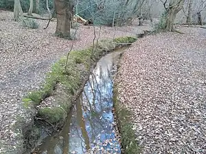
Loughton Brook is a stream located in Loughton, Essex, United Kingdom. It runs for 4.18 Km from just north of Epping New Road, near Wake Valley Ponds, to the River Roding 200 metres south of South Loughton Cricket Club. In the past, Loughton Brook has flooded on several occasions, especially around the Loughton High Road/The Drive and Valley Hill/Roding Road junctions.[1] As a result, a flood control dam was constructed just north of Staples Road, and most of the section through Loughton runs underground. Despite this, Loughton Brook still poses a significant flood risk,[2] with several areas (Roding Valley High School, the High Road outside Morrison's and the area around Avondale Road and Malvern Gardens) having flooded previously, and are in flood zone 3,[3] indicating a 1 in a 100 chance of flooding in any given year.[4] However, the brook is unlikely to flood as it did previously due to the construction of the dam at Staples Road. The brook is dammed at three places along its route; at Wake Valley Ponds (next to Epping New Road), at Baldwin's pond, and just north of Staples Road, (for flood prevention).[5]
References
- ↑ "About Loughton - Background". www.loughtonresidents.co.uk. Retrieved 2019-12-30.
- ↑ "Bridge House flood risk assessment" (PDF). Epping Forest District Council. March 19, 2015. Archived from the original (PDF) on 2019-12-30. Retrieved 2019-12-30.
- ↑ "Flood map for planning - GOV.UK". flood-map-for-planning.service.gov.uk. Retrieved 2019-12-30.
- ↑ Stone, Angharad. "Flood Map for Planning Risk". United Kingdom. Retrieved 2019-12-30.
- ↑ "OpenStreetMap". OpenStreetMap. Retrieved 2019-12-29.