Lowell, Michigan | |
|---|---|
| City of Lowell | |
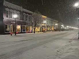
 Historic district along Main Street (M-21) | |
| Nickname: "Sidewinders” | |
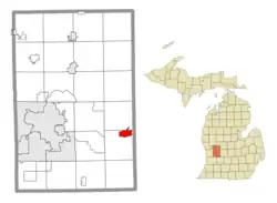
 Location within Kent County | |
 Lowell Location within the state of Michigan  Lowell Location within the United States | |
| Coordinates: 42°56′06″N 85°20′45″W / 42.93500°N 85.34583°W | |
| Country | United States |
| State | Michigan |
| County | Kent |
| Founded | 1831 |
| Government | |
| • Type | Mayor–council |
| • Mayor | Michael DeVore & Dominick Ronchetti |
| • Clerk | Amy Brown |
| • Manager | Michael Burns |
| Area | |
| • Total | 3.10 sq mi (8.03 km2) |
| • Land | 2.88 sq mi (7.46 km2) |
| • Water | 0.22 sq mi (0.57 km2) |
| Elevation | 640 ft (200 m) |
| Population (2020) | |
| • Total | 4,142 |
| • Density | 1,438.19/sq mi (555.29/km2) |
| Time zone | UTC-5 (Eastern (EST)) |
| • Summer (DST) | UTC-4 (EDT) |
| ZIP code(s) | 49331 |
| Area code | 616 |
| FIPS code | 26-49540[3] |
| GNIS feature ID | 1626644[2] |
| Website | Official website |
Lowell is a city in Kent County of the U.S. state of Michigan. The population was 3,783 at the 2010 census.
Lowell is part of the Grand Rapids metropolitan area and is about 15 miles (24.1 km) east of the city of Grand Rapids. The city is mostly surrounded by Lowell Township to the south, but the two are administered autonomously. Lowell is situated just north of where the Flat River meets the Grand River. The city's downtown area is listed on the National Register of Historic Places as the Downtown Lowell Historic District.
History
The earliest modern residents of the Flat River and Grand River were the Grand River Odawa, who established several villages along the Grand River. In the first decades of the 19th century, the village was led by Wabiwindego and Keewaycooshcum, and later by Cobmoosa.[4] In the 1830s, Cobmoosa purchased the land under the Odawa village in the name of his father, fur trader Antoine Campau.[5] The Odawa remained at their village on the Flat River until 1858, when they moved to a reservation at Manistee, Michigan.[6]
The modern city of Lowell was founded in 1831 by Daniel Marsac as a trading post with this existing Odawa village, built on the south bank of the Grand River.[7] During the first years of his trading post, Marsac lived with the Grand River Odawa leader Wabiwindego.[7] In 1847, he purchased land on the north side of the river and platted it as "Dansville". In 1851, a post office was established there named "Lowell" after the township. The community was replatted in 1854 and renamed after the post office. It incorporated as a village in 1861.[8]
Geography
According to the U.S. Census Bureau, the city has a total area of 3.10 square miles (8.03 km2), of which 2.88 square miles (7.46 km2) is land and 0.22 square miles (0.57 km2) (7.10%) is water.[9]
Lowell is the home of the North Country Trail Association.[10] In the Lowell area, the trail runs just north of downtown and along portions of the Flat River.
Major highways
 M-21 runs east and west through the center of the community.
Climate
This climatic region is typified by large seasonal temperature differences, with warm to hot (and often humid) summers and cold (sometimes severely cold) winters. According to the Köppen Climate Classification system, Lowell has a humid continental climate, abbreviated "Dfb" on climate maps.[11]
Demographics
| Census | Pop. | Note | %± |
|---|---|---|---|
| 1860 | 547 | — | |
| 1870 | 1,503 | 174.8% | |
| 1880 | 1,538 | 2.3% | |
| 1890 | 1,829 | 18.9% | |
| 1900 | 1,736 | −5.1% | |
| 1910 | 1,761 | 1.4% | |
| 1920 | 1,730 | −1.8% | |
| 1930 | 1,919 | 10.9% | |
| 1940 | 1,944 | 1.3% | |
| 1950 | 2,191 | 12.7% | |
| 1960 | 2,545 | 16.2% | |
| 1970 | 3,068 | 20.6% | |
| 1980 | 3,707 | 20.8% | |
| 1990 | 3,983 | 7.4% | |
| 2000 | 4,013 | 0.8% | |
| 2010 | 3,783 | −5.7% | |
| 2020 | 4,142 | 9.5% | |
| U.S. Decennial Census[12] | |||
2010 census
As of the census[13] of 2010, there were 3,783 people, 1,457 households, and 962 families living in the city. The population density was 1,313.5 inhabitants per square mile (507.1/km2). There were 1,581 housing units at an average density of 549.0 per square mile (212.0/km2). The racial makeup of the city was 94.1% White, 1.3% African American, 0.6% Native American, 0.6% Asian, 1.1% from other races, and 2.3% from two or more races. Hispanic or Latino of any race were 3.0% of the population.
There were 1,457 households, of which 36.4% had children under the age of 18 living with them, 45.8% were married couples living together, 15.5% had a female householder with no husband present, 4.7% had a male householder with no wife present, and 34.0% were non-families. 29.0% of all households were made up of individuals, and 10.2% had someone living alone who was 65 years of age or older. The average household size was 2.50 and the average family size was 3.04.
The median age in the city was 37.1 years. 25.7% of residents were under the age of 18; 8.9% were between the ages of 18 and 24; 25.1% were from 25 to 44; 25.2% were from 45 to 64; and 15% were 65 years of age or older. The gender makeup of the city was 46.3% male and 53.7% female.
2000 census
As of the census[3] of 2000, there were 4,013 people, 1,492 households, and 1,008 families living in the city. The population density was 1,391.2 inhabitants per square mile (537.1/km2). There were 1,564 housing units at an average density of 542.2 per square mile (209.3/km2). The racial makeup of the city was 96.21% White, 0.57% African American, 0.62% Native American, 0.42% Asian, 0.12% Pacific Islander, 0.72% from other races, and 1.32% from two or more races. Hispanic or Latino of any race were 2.14% of the population.
There were 1,492 households, out of which 38.7% had children under the age of 18 living with them, 49.1% were married couples living together, 14.0% had a female householder with no husband present, and 32.4% were non-families. 26.7% of all households were made up of individuals, and 10.9% had someone living alone who was 65 years of age or older. The average household size was 2.59 and the average family size was 3.17.
In the city, the population was spread out, with 29.3% under the age of 18, 8.5% from 18 to 24, 30.8% from 25 to 44, 17.6% from 45 to 64, and 13.8% who were 65 years of age or older. The median age was 34 years. For every 100 females, there were 89.0 males. For every 100 females age 18 and over, there were 85.8 males.
The median income for a household in the city was $42,326, and the median income for a family was $49,145. Males had a median income of $36,525 versus $25,625 for females. The per capita income for the city was $17,843. About 4.4% of families and 6.0% of the population were below the poverty line, including 5.3% of those under age 18 and 7.5% of those age 65 or over.
Recreation
Education
Lowell Area Schools is the local school district. Bushnell and Cherry Creek elementary schools serve the city itself. Lowell Middle School and Lowell High School serve the entire school district.[14]
Notable people
- William Seward Burroughs I, adding machine inventor, founder of the Burroughs Corporation and grandfather of Beat Generation author William S. Burroughs lived in Lowell in the 1860s and graduated from Lowell High School.
- Cobmoosa, operated a trading post where Lowell exists now.[15]
- Mike Dumas, professional football player (retired)
- Mabel Gillespie, farmer, teacher, journalist, politician, lived in Lowell from 1958 to 1967.[16]
- Ernest R. Graham, designer of Chicago landmarks such as the Wrigley Building, Shedd Aquarium, etc., born in Lowell.
- Jennie Harris Oliver, poet, born in Lowell.[17]
- Dave Hildenbrand, Michigan politician[18]
- Anthony Kiedis, Red Hot Chili Peppers lead singer.
- Howard Henry Peckham, professor and historian, Lowell High School graduate.[19]
- Ann Rule, author of true crime novels, born in Lowell, Michigan[20]
- John Addison Scott, U.S. Navy Rear Admiral and Navy Cross recipient.[21]
- Glendon Swarthout, novelist, graduated from Lowell High School.
- Daniel Vosovic, fashion designer, Lowell High School graduate.[22]
References
- ↑ "2020 U.S. Gazetteer Files". United States Census Bureau. Retrieved May 21, 2022.
- 1 2 U.S. Geological Survey Geographic Names Information System: Lowell, Michigan
- 1 2 "U.S. Census website". United States Census Bureau. Retrieved 2008-01-31.
- ↑ Hartz, Bennett (July 1, 2019). "Wabaningo: An Odawa Leader and Legend". Michigan History. Lansing, MI: Historical Society of Michigan. Retrieved July 9, 2021.
- ↑ McClurken, James M. (2009). Our People, Our Journey: The Little River Band of Odawa Indians. East Lansing, MI: Michigan State University Press. p. 38. ISBN 9780870138560.
- ↑ Romig, Walter (1986). Michigan Place Names: The History of the Founding and the Naming of More Than Five Thousand Past and Present Michigan Communities. Detroit: Wayne State University Press. p. 123. ISBN 9780814318386.
- 1 2 Collections and Researches Made by the Pioneer and Historical Society of the State of Michigan. Lansing, MI: Wynkoop Hallenbeck Crawford Company. 1912. p. 60. ISBN 9780282377953.
- ↑ Romig, Walter (1986) [1973]. Michigan Place Names. Detroit, Michigan: Wayne State University Press. ISBN 0-8143-1838-X.
- ↑ "US Gazetteer files 2010". United States Census Bureau. Archived from the original on 2012-07-02. Retrieved 2012-11-25.
- ↑ "North Country Trail Association". Retrieved 18 January 2011.
- ↑ "Lowell, Michigan Climate Classification (Weatherbase)". Weatherbase.
- ↑ "Census of Population and Housing". Census.gov. Retrieved June 4, 2015.
- ↑ "U.S. Census website". United States Census Bureau. Retrieved 2012-11-25.
- ↑ "lowell_schools_map.pdf" (PDF). Lowell Area Schools. Archived (PDF) from the original on 2021-02-23. Retrieved 2021-02-23. - Elementary school boundary descriptions here (see text for information on Bushnell and Cherry Creek elementaries)
- ↑ "The Ludington Daily News from Ludington, Michigan on November 29, 1957 · Page 8".
- ↑ Omaha World Herald, November 26, 1982, page 4
- ↑ Holliday, Shawn; Barnes, Jim; Brown, Nathan L.; Davis, Delbert; Fry, Maggie Culver; Hamilton, Carol; Hill, Rudolph N.; Kreger, Joe; Kroeger, Paul (2015). The Oklahoma poets laureate : a sourcebook, history, and anthology. Mongrel Empire Press. ISBN 9780990320432.
- ↑ "Senator Dave Hildenbrand". Michigan Senate Republicans. Archived from the original on 4 December 2010. Retrieved 17 January 2011.
- ↑ "Memorial | Faculty History Project".
- ↑ "Ann Rule Bio". Archived from the original on 2012-05-20. Retrieved 2015-08-01.
- ↑ "John Addison Scott". Military Times. Retrieved 17 December 2021.
- ↑ "Project Runway - Daniel Vosovic's Bio is Available Online - Official Bravo TV Site". Archived from the original on 2007-10-10. Retrieved 2019-05-09.
