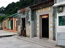


Luk Keng (Chinese: 鹿頸; lit. 'deer's neck') is an area in the North District of Hong Kong.
Administration
Luk Keng is one of the villages represented within the Sha Tau Kok District Rural Committee. For electoral purposes, Luk Keng is part of the Sha Ta constituency, which is currently represented by Ko Wai-kei.[1][2]
Location
Luk Keng is located in the northeastern part of the New Territories, to the south west of Sha Tau Kok, east of Nam Chung and to the south of the Starling Inlet (Sha Tau Kok Hoi).
History
At the time of the 1911 census, the population of Luk Keng was 484. The number of males was 182.[3]
Villages
Luk Keng contains several villages, including:
- Luk Keng Chan Uk (鹿頸陳屋)
- Luk Keng Lam Uk (鹿頸林屋)
- Luk Keng Wong Uk (鹿頸黃屋)
Features
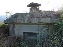
Luk Keng is the site of a World War II network of defense, comprising a trench system and 14 pillboxes, built during the Japanese occupation of Hong Kong. The network is located on a 120 m hill overlooking Starling Inlet.[4][5][6] The Luk Keng Pillboxes and Observation Posts have been listed as Grade II historic buildings.[7]
Transportation
The closest station to Luk Keng on the MTR is Fanling station. Green minibus No. 56K runs to the Luk Keng terminus.
References
- ↑ "Recommended District Council Constituency Areas (North District)" (PDF). Electoral Affairs Commission. Retrieved 19 October 2021.
- ↑ "North District Council - North DC Members". District Council. Retrieved 19 October 2021.
- ↑ Hase, Patrick (1996). "Traditional Life in the New Territories: The Evidence of the 1911 and 1921 Censuses" (PDF). Journal of the Royal Asiatic Society Hong Kong Branch. 36: 77. ISSN 1991-7295.
- ↑ Antiquities Advisory Board. Historic Building Appraisal. Luk Keng Pillboxes and Observation Posts
- ↑ Choy, Gigi (7 March 2021). "Hong Kong military heritage researchers dismayed to find World War II relics in state of neglect". South China Morning Post.
- ↑ "Survey Findings on Japanese World War II Military Installations in Hong Kong" (PDF). Surveying & Built Environment. Hong Kong Institute of Surveyors (Special issue to commemorate the 70th Anniversary of the Battle of Hong Kong, 8 December to 25 December 1941): 79–83. 2011.
- ↑ Antiquities Advisory Board. List of the 1,444 Historic Buildings with Assessment Results
External links
- Approved Luk Keng and Wo Hang Outline Zoning Plan
- Pictures of Luk Keng
- Pictures of Luk Keng pillboxes
22°31′32″N 114°12′55″E / 22.52556°N 114.21528°E