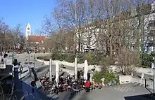

The Münchner Freiheit (called Münchener Freiheit until 1998)[1] is a square in Munich's Schwabing, near the English Garden. It is a popular tourist attraction, especially during winter when one of Munich's largest Christmas markets takes place.[2][3]
The square's Munich U-Bahn station is Münchner Freiheit.[4][5]
A German pop group, Münchener Freiheit, derived their name from the location, and have retained the original spelling.[6][7][8][9]
Origin of the name
The square at Leopoldstraße was originally known as Feilitzsch Platz, after a Bavarian interior minister. In 1933 it was renamed Danziger Freiheit or "Danzig freedom", in expression of the wish to see the city of Danzig returned to German rule. In tribute to an anti-Nazi resistance group, Freiheitsaktion Bayern, who had taken over two Munich radio towers in 1945, the name Münchener Freiheit or "Munich freedom" was selected following the war.[10] The alternative spelling Münchner Freiheit was adopted by the city council in 1998 though Münchener Freiheit remains popular.
References
- ↑ Luck, Harry (1998-11-25). "Die "Münchener Freiheit" verliert ein "e"". Rhein-Zeitung (in German). Archived from the original on 2017-01-07.
- ↑ "Christmas Markets Munich: Shopping in Winter - Overview". Munich FOR A VISIT. Retrieved 2023-10-22.
- ↑ "Munich Christmas Markets 2023". www.christmasmarketsgermany.com. Retrieved 2023-10-22.
- ↑ "Münchner Freiheit | MVV". www.mvv-muenchen.de (in German). Retrieved 2023-10-22.
- ↑ "THE 10 BEST Things to Do Near Munchner Freiheit Station, Munich". www.tripadvisor.com. Retrieved 2023-10-22.
- ↑ "Münchener Freiheit". Discogs. Retrieved 2023-10-22.
- ↑ "Münchener Freiheit on Apple Music". Apple Music - Web Player. Retrieved 2023-10-22.
- ↑ "Münchener Freiheit - Anniversary Concert | Deutsches Theater München". 2020-02-17. Retrieved 2023-10-22.
- ↑ "Münchener Freiheit( Munchener Freiheit ) 7 albums 56 lyrics ※ Mojim.com". MOJIM. Retrieved 2023-10-22.
- ↑ "Places of Remembrance and Commemoration" (PDF). Landeshauptstadt München Kulturreferat/NS-Dokumentationszentrum. 2010. pp. 104–105. Archived from the original (PDF) on 2012-04-25. Retrieved 2011-11-09.