Mýto pod Ďumbierom | |
|---|---|
Village | |
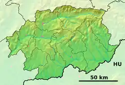 Mýto pod Ďumbierom Location of Mýto pod Ďumbierom in the Banská Bystrica Region  Mýto pod Ďumbierom Mýto pod Ďumbierom (Slovakia) | |
| Coordinates: 48°51′N 19°38′E / 48.850°N 19.633°E | |
| Country | Slovakia |
| Region | Banská Bystrica |
| District | Brezno |
| First mentioned | 1260 |
| Area | |
| • Total | 10.389 km2 (4.011 sq mi) |
| Elevation | 630 m (2,070 ft) |
| Population (2004-12-31) | |
| • Total | 542 |
| • Density | 52/km2 (140/sq mi) |
| Postal code | 976 44 |
| Area code | +421-48 |
| Car plate | BR |
| Website | www.mytopoddumbierom.sk |
Mýto pod Ďumbierom (Hungarian: Vámos) is a village and municipality in Brezno District, in the Banská Bystrica Region of central Slovakia.
Municipalities of Brezno District | ||
|---|---|---|
This article is issued from Wikipedia. The text is licensed under Creative Commons - Attribution - Sharealike. Additional terms may apply for the media files.