MacArthur Square | |||||||||||
|---|---|---|---|---|---|---|---|---|---|---|---|
| The Tide light rail station | |||||||||||
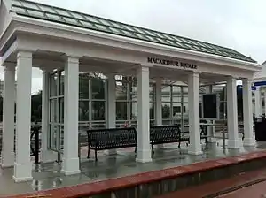
 The waiting area in January 2011 prior to opening. | |||||||||||
| General information | |||||||||||
| Location | City Hall Avenue at Bank Street Norfolk, VA | ||||||||||
| Coordinates | 36°50′50″N 76°17′23″W / 36.8472°N 76.2897°W | ||||||||||
| Owned by | Hampton Roads Transit | ||||||||||
| Platforms | 2 side platforms | ||||||||||
| Tracks | 2 | ||||||||||
| Connections | |||||||||||
| Construction | |||||||||||
| Structure type | At-grade | ||||||||||
| Bicycle facilities | Racks available | ||||||||||
| Accessible | Yes | ||||||||||
| History | |||||||||||
| Opened | August 19, 2011 | ||||||||||
| Services | |||||||||||
| |||||||||||
MacArthur Square is a Tide Light Rail station in Norfolk, Virginia. Opened in August 2011, it is situated in downtown Norfolk in a small block bounded by Plume Street, City Hall Avenue, Bank Street and Atlantic Street.[1]
The station is adjacent to the MacArthur Center, MacArthur Memorial (former Norfolk City Hall), the Norfolk Library Downtown Branch, the business district along Main Street, Waterside Festival Marketplace, Nauticus, and many of downtown's larger hotels.[1] This station is also the closest to HRT's Elizabeth River Ferry service to Downtown Portsmouth.
References
- 1 2 Hampton Roads Transit. "MacArthur Square station". Retrieved 2011-07-24.
External links
 Media related to MacArthur Square (Tide station) at Wikimedia Commons
- MacArthur Square station
This article is issued from Wikipedia. The text is licensed under Creative Commons - Attribution - Sharealike. Additional terms may apply for the media files.