| Maclure Glacier | |
|---|---|
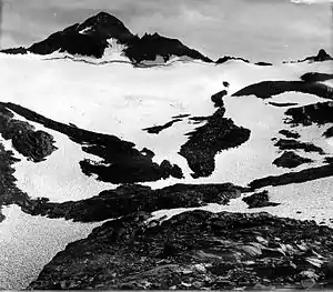
 Mount Maclure and Maclure Glacier. Circa 1917 | |
 Maclure Glacier Location in California | |
| Type | Mountain glacier |
| Location | Mount Maclure, Yosemite National Park, Tuolumne County, California, U.S. |
| Coordinates | 37°44′48″N 119°16′58″W / 37.74667°N 119.28278°W[1] |
| Area | .08 sq mi (0.21 km2) |
| Length | .20 mi (0.32 km) |
| Terminus | Talus |
| Status | Retreating |
Maclure Glacier (also McClure Glacier) is on Mount Maclure in the Sierra Nevada crest of Yosemite National Park in Tuolumne County, California, United States.[2] The glacier is named after William Maclure.[1] Like most glaciers in the Sierra Nevada, Maclure Glacier is a small cirque glacier that is .20 mi (0.32 km) long and covers an area of only .08 sq mi (0.21 km2). The mean elevation of the glacier is around 11,400 ft (3,500 m).[3] Both the Maclure Glacier and the Lyell Glacier, located nearby on Mount Lyell, have retreated since their first discovery.[4]
See also
References
- 1 2 "Maclure Glacier". Geographic Names Information System. United States Geological Survey, United States Department of the Interior. Retrieved September 30, 2012.
- ↑ Mount Lyell, CA (Map). TopoQwest (United States Geological Survey Maps). Retrieved September 30, 2012.
- ↑ "Geological Survey Professional Paper 715—B Combined Ice and Water Balances of Maclure Glacier, California, South Cascade Glacier, Washington, and Wolverine and Gulkana Glaciers, Alaska, 1967 Hydrologic Year". USGS. March 28, 2006. Retrieved October 15, 2007.
- ↑ "Twenthieth Century Glacier Change in the Sierra Nevada, California". Hassan Basagic. May 14, 2005. Archived from the original on September 6, 2006. Retrieved January 11, 2007.
This article is issued from Wikipedia. The text is licensed under Creative Commons - Attribution - Sharealike. Additional terms may apply for the media files.