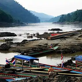
Mae Sam Laep
แม่สามแลบ | |
|---|---|
 | |
| Coordinates: 17°58′30″N 97°44′21″E / 17.97500°N 97.73917°E | |
| Country | Thailand |
| Province | Mae Hong Son |
| District | Sop Moei |
| Population (2005) | |
| • Total | 9,802 |
| Time zone | UTC+7 (ICT) |
Mae Sam Laep (Thai: แม่สามแลบ) is a village and tambon (sub-district) of Sop Moei District, in Mae Hong Son Province, Thailand.[1] In 2005 it had a population of 9,802. The tambon contains 10 villages. Mae Sam Laep lies on the Salween River which marks the border with Myanmar.[2]
References
- ↑ Thaitambon.com, Accessed 21 July 2011 (in Thai)
- ↑ Wongcha-um, Panu (30 March 2021). "Some Myanmar wounded cross into Thailand, others sent back". Reuters. Retrieved 28 April 2021.
This article is issued from Wikipedia. The text is licensed under Creative Commons - Attribution - Sharealike. Additional terms may apply for the media files.