Mahua | |
|---|---|
Community Development Block | |
| Mahua | |
 Mahua Location in bihar , India | |
| Coordinates: 25°48′44.0″N 85°23′48.0″E / 25.812222°N 85.396667°E | |
| Country | |
| State | Bihar |
| Region | Mithila |
| District | vaishali |
| District Sub-division | Mahua [1] |
| Anchal | Mahua[1] |
| Vidhan Sabha constituency | Mahua [2] |
| Government | |
| • Type | Community development block |
| Population (2001) | |
| • Total | 218,344[1] |
| Languages | |
| • Official | Hindi |
| Time zone | UTC+5:30 (IST) |
| ISO 3166 code | IN-BR |

The Mahua-Patna route.
Mahua is a block and sub-division in Vaishali district, it is a small town between Hajipur to Muzaffarpur, Mahua is also a constituent assembly under Bihar Legislative Assembly. It comes under Hajipur Lok Sabha (Lower house of Indian Parliament) constituency [3] [1]
Population and communities
- Male Population : 113240 (2009 ist.)
- female Population : 105104
- Total Population : 218344
- SC Total Population : 48231
- ST Total Population : 3
- Minority Total Population : 23924
- Population Density : 1559
- Sex Ratio : 928
Gallery

A skill development centre near Mahua, established as a part of Pradhanmantri Kaushal Vikas Yojna.
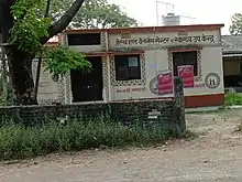
A health and wellness centre near Mahua.

A petrol pump located in the Hajipur-Mahua road.
See also
References
- 1 2 3 4 5 "Vaishali at a Glance" (PDF). vaishali.bih.nic.in. Archived from the original (PDF) on 3 March 2016. Retrieved 24 November 2014.
- ↑ mahua Assembly constituency -- chief Electoral Officer official website
- ↑ "BLOCK DEVELOPMENT OFFICER -- vaishali district official website". Archived from the original on 2014-09-28. Retrieved 2014-11-26.
This article is issued from Wikipedia. The text is licensed under Creative Commons - Attribution - Sharealike. Additional terms may apply for the media files.