| Mangakino Caldera | |
|---|---|
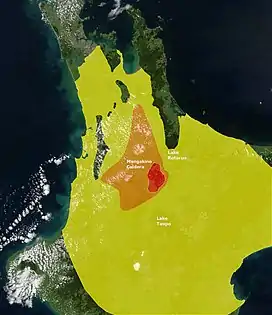
 Approximate extent of ignimbrite sheets from Kidnappers (yellow) and Rocky Hill eruptions (orange) as determined from land drill cores sampling. The Kidnappers ignimbrite has been reported in some cores from just beyond the boundaries shown and this map only tries to show where there was full coverage of the then existing landforms and present land surface to convey an idea of the minimal total biosphere disruption.[1][2][3] | |
| Highest point | |
| Coordinates | 38°23′S 175°47′E / 38.383°S 175.783°E |
| Dimensions | |
| Length | 30 km (19 mi)[3] |
| Width | 15 km (9.3 mi)[3] |
| Geography | |
 Mangakino Caldera | |
| Geology | |
| Age of rock | |
| Mountain type | Caldera |
| Volcanic arc/belt | Taupo Volcanic Zone |
| Last eruption | 900,000 years ago[3] |

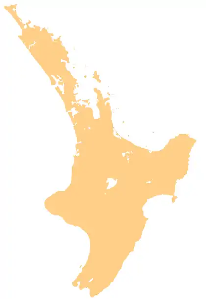
The Mangakino caldera complex (other names are Mangakino volcanic center, Mangakino Caldera) is the westernmost and one of oldest extinct rhyolitic caldera volcanoes in the Taupō Volcanic Zone of New Zealand's North Island.[4] It produced about a million years ago (1 Ma) in the Kidnappers eruption of 1,200 km3 (287.9 cu mi), the most widespread ignimbrite deposits on Earth being over 45,000 km2 (17,000 sq mi)[1] and was closely followed in time by the smaller 200 km3 (48.0 cu mi) Rocky Hill eruption.[5] The Kidnappers eruption had a estimated VEI of 8 and has been assigned a total eruption volume (not just tephra) of 2,760 km3 (662.2 cu mi).
However this was only in its most recent caldera forming phase from 1.21 to 0.91 million years ago as it had its earliest caldera generating phase from 1.62 to 1.51 million years ago.[1] There are at least 11 major historic eruptions assigned to this complex.[6] At least 5 of these contributed significant welded ignimbrite deposits that represent major pyroclastic events in the central North Island.[2] Ongatiti Ignimbrite (Hinuera Stone) from a 7 VEI event,[7] about 1.3 million years ago, has now been found over a wider area and several meter thick tephra deposits from the eruption exist on drill samples from both Auckland and Wellington.[8][9]
The earliest characterised eruptives from the complex are andesitic[10] and the mechanism of transition from this to the more explosive later rhyolitic eruptions is related to increased heat flow from the magma sources.[11]
Later many of these deposits were covered over by deposits from other eruptive centres such as those of the Oruanui eruption.
The caldera can be defined by gravitational measurements as 30 km (19 mi) by 15 km (9.3 mi) and its "basement" floor is at least 4 km (2.5 mi) below the present ground surface.[3]
| Formations | Layer names | Age range estimate by various methods (if only one method ± error) | Eruptive volume |
|---|---|---|---|
| Marshall | Unit I (Marshall A and B) Ignimbrite Unit H (Kaahu) Ignimbrite Unit G | 0.95 ± 0.03 Ma | |
| Whakaahu | Rhyolite dome | 1.02 ± 0.02 Ma | |
| Raepahu (Potaka Tephra)[1] | Rocky Hill Ignimbrite Kidnappers Unit E Ignimbrite and fall deposit | 0.95 to 1.15 Ma 0.93 to 1.07 Ma | 200 cubic kilometres (48 cu mi) >1,200 cubic kilometres (290 cu mi) |
| Mangaokewa | Ahuroa Ignimbrite Unit D Ignimbrite and fall deposit | 1.16 to 1.33 Ma 1.20 ± 0.04 Ma | |
| Ongatiti | Ongatiti Ignimbrite (Oparau tephra, K12a Kauroa Ash Formation, K12)[12] Tumai Rd dome | 1.37 ± 0.04 Ma (1.31 ± 0.09 Ma, 1.38 ± 0.06 Ma, 1.38 ± 0.05 Ma)[13] 1.16 to 1.34 Ma 1.27 ± 0.05 Ma | >1,000 cubic kilometres (240 cu mi) DRE[9] |
| Pouakani | Unit C Ignimbrite | 1.68 ± 0.07 Ma (This age inconsistent with position) | |
| Tolley | Unit B Ignimbrite | 1.53 ± 0.04 Ma | |
| Ngaroma | Ngaroma (Unit A) Ignimbrite | 1.31 to 1.6 Ma | |
| Link (source unknown) | Unit F Ignimbrite | 1.60 ± 0.09 Ma |
Geological understanding
That there was a separate Mangakino volcanic complex was first understood in 1965,[14] and a caldera structure by gravity studies in 1982.[14] The recognition was impaired mainly because of erosion produced discontinuities, burying by later volcanic deposits or overburden displacement in later caldera formation. The extent of eastern ignimbrite deposits from the early Ongatiti event is still unknown and even the eastern caldera boundary is ill defined due to the very disruptive margins of the new Taupō Rift to the east of the complex. At Tokoroa to the complexes north, Ongatiti ignimibrite is for example found at a depth of between 392 to 457 m (1,286 to 1,499 ft).[15][16]
What are now termed ignimbrites and manifest as prominent surface deposits, far from the complex, were recognised by Ferdinand von Hochstetter in his 1859 maps.[17] From the early 1960s the various ignimbrites from the complex were assigned names and studied in more detail.[17] Colin Wilson first defined the Mangakino caldera complex in 1964 and went on to improve the understanding of its ignimbrite distribution and stratigraphy.[17] Reliable age data became available from the 1990s.[17] It was in the late 1990s that it first became recognised that the size of the eruptions had been underestimated,[16] but not until 2016–17 that proof of super eruptions was presented.[1]
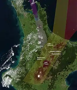
The Mangakino caldera eruptives are definitely assignable to the Taupō Volcanic Zone but are to the west of the currently most active portion of the Taupō Rift.[1] To its north the transition between the north-western Taupō Rift and the Coromandel Volcanic Zone via the Tauranga Volcanic Centre and its 2.1 million year old Waiteariki Formation are subject to on going study.[18]
References
- 1 2 3 4 5 6 Cooper et al. 2016
- 1 2 Spinks, Karl D. (2005). "Rift Architecture and Caldera Volcanism in the Taupo Volcanic Zone, New Zealand".
- 1 2 3 4 5 6 7 Pittari et al. 2021
- ↑ Krippner, Stephen J. P.; Briggs, Roger M.; Wilson, Colin J. N.; Cole, James W. (1998). "Petrography and geochemistry of lithic fragments in ignimbrites from the Mangakino Volcanic Centre: implications for the composition of the subvolcanic crust in western Taupo Volcanic Zone, New Zealand". New Zealand Journal of Geology and Geophysics. 41 (2): 187–199. doi:10.1080/00288306.1998.9514803.
- ↑ Cooper, G.F.; C. J. Wilson; J. A. Baker; M. Millet (2012). "Rejuvenation and Repeated Eruption of a 1.0 Ma Supervolcanic System at Mangakino Caldera, Taupo Volcanic Zone, New Zealand". AGU Fall Meeting Abstracts. 2012. Bibcode:2012AGUFM.V31C2797C. Retrieved 2022-05-15.
- ↑ "Mangakino". VOGRIPA. Archived from the original on 9 December 2018. Retrieved 9 December 2018.
- ↑ Yousef Zadeh 2020, pp. ii.
- ↑ Yousef Zadeh 2020, p. 38.
- 1 2 Yousef Zadeh et al. 2023, Conclusions
- 1 2 Yousef Zadeh 2020, table 1.1
- ↑ Yousef Zadeh 2020, p. 9
- ↑ Yousef Zadeh 2020, p. 150.
- ↑ Yousef Zadeh et al. 2023, Compilation of published ages and new (Usingle bondTh)/He data.
- 1 2 Yousef Zadeh 2020, p. 8
- ↑ Houghton, B; Wilson, C; Stern, T (1987). J Begg (ed.). New Zealand Geological Survey Record: Ignimbrite stratigraphy of a 457 m deep drillhole near Tokoroa. Vol. 20. New Zealand Geological Survey, Lower Hutt. pp. 51–53. ISSN 0112-465X.
- 1 2 Yousef Zadeh 2020, p. 12
- 1 2 3 4 Yousef Zadeh 2020, p. 11
- ↑ Prentice, Marlena; Pittari, Adrian; Lowe, David J.; Kilgour, Geoff; Kamp, Peter J.J.; Namaliu, Miriam (2022). "Linking proximal ignimbrites and coeval distal tephra deposits to establish a record of voluminous Early Quaternary (2.4–1.9 Ma) volcanism of the Tauranga Volcanic Centre, New Zealand". Journal of Volcanology and Geothermal Research. 429 (107595): 107595. doi:10.1016/j.jvolgeores.2022.107595. ISSN 0377-0273. S2CID 249264293.
- Sources
- Cooper, George F; Wilson, Colin; Millet, Marc-Alban; Baker, Joel (2016). "Generation and Rejuvenation of a Supervolcanic Magmatic System: a Case Study from Mangakino Volcanic Centre, New Zealand". Journal of Petrology. 57 (6): 1135–1170. doi:10.1093/petrology/egw035.
- Yousef Zadeh, E. (2020). Eruption and emplacement of the 1.3-Ma Ongatiti Ignimbrite, New Zealand: Regional pathways, particle processes, and pumice evolution associated with a large-volume pyroclastic flow deposit (PhD). The University of Waikato, Hamilton, New Zealand. hdl:10289/14063.
- Pittari, Adrian; Prentice, Marlena L.; McLeod, Oliver E.; Yousef Zadeh, Elham; Kamp, Peter J. J.; Danišík, Martin; Vincent, Kirsty A. (2021). "Inception of the modern North Island (New Zealand) volcanic setting: spatio-temporal patterns of volcanism between 3.0 and 0.9 Ma" (PDF). New Zealand Journal of Geology and Geophysics. 64 (2–3): 250–272. doi:10.1080/00288306.2021.1915343. S2CID 235736318.
- Yousef Zadeh, Elham; Pittari, Adrian; Lowe, David J.; Danišík, Martin (2023). "Mobility and emplacement of an ancient, large-volume pyroclastic flow, Ongatiti Ignimbrite, North Island, New Zealand". Journal of Volcanology and Geothermal Research. 440 (107853): 107853. doi:10.1016/j.jvolgeores.2023.107853. ISSN 0377-0273. S2CID 259551526.