Mannsdorf an der Donau | |
|---|---|
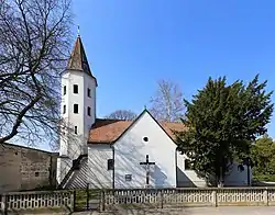 Church in Mannsdorf an der Donau | |
 Coat of arms | |
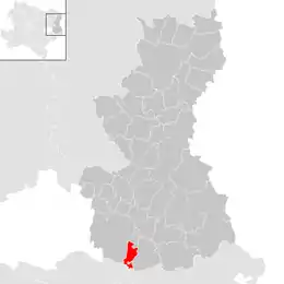 Location within Gänserndorf district | |
 Mannsdorf an der Donau Location within Austria | |
| Coordinates: 48°9′N 16°36′E / 48.150°N 16.600°E | |
| Country | Austria |
| State | Lower Austria |
| District | Gänserndorf |
| Government | |
| • Mayor | Christoph Windisch (ÖVP) |
| Area | |
| • Total | 10.31 km2 (3.98 sq mi) |
| Elevation | 151 m (495 ft) |
| Population (2018-01-01)[2] | |
| • Total | 342 |
| • Density | 33/km2 (86/sq mi) |
| Time zone | UTC+1 (CET) |
| • Summer (DST) | UTC+2 (CEST) |
| Postal code | 2304 |
| Area code | +43 2212 |
| Website | www |
Mannsdorf an der Donau is a town in the district of Gänserndorf in the Austrian state of Lower Austria.
Geography
Mannsdorf an der Donau lies on the southern edge of the Marchfeld in the Weinviertel in Lower Austria. About 12 percent of the municipality is forested.
References
- ↑ "Dauersiedlungsraum der Gemeinden Politischen Bezirke und Bundesländer - Gebietsstand 1.1.2018". Statistics Austria. Retrieved 10 March 2019.
- ↑ "Einwohnerzahl 1.1.2018 nach Gemeinden mit Status, Gebietsstand 1.1.2018". Statistics Austria. Retrieved 9 March 2019.
This article is issued from Wikipedia. The text is licensed under Creative Commons - Attribution - Sharealike. Additional terms may apply for the media files.