Mappi Regency
Kabupaten Mappi | |
|---|---|
 Coat of arms | |
| Motto(s): Usubi Yohokuda - Tako Bayaman (Peace in One Heart - Serving Each Other) | |
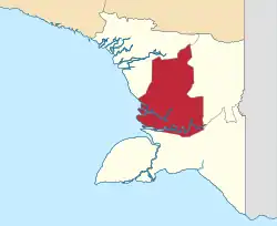 | |
 Mappi Regency Location in Western New Guinea and Indonesia  Mappi Regency Mappi Regency (Indonesia) | |
| Coordinates: 6°29′59″S 139°20′40″E / 6.4997°S 139.3444°E | |
| Country | |
| Province | South Papua |
| Capital | Kepi |
| Government | |
| • Regent | Kristosimus Agawemu |
| • Vice Regent | Ibnu Jaya Suud |
| Area | |
| • Total | 25,609.94 km2 (9,888.05 sq mi) |
| Population (mid 2022 estimate)[1] | |
| • Total | 111,141 |
| • Density | 4.3/km2 (11/sq mi) |
| Time zone | UTC+9 (Indonesia Eastern Time) |
| Area code | (+62) 411 |
| Website | mappikab.go.id |
Mappi Regency is a regency (kabupaten) in the Indonesian province of South Papua. It was split off from Merauke Regency (of which it had been a component part) on 12 November 2002. It covers an area of 25,609.94 km2, and had a population of 81,658 at the 2010 Census[2] and 108,295 at the 2020 Census;[3] the official estimate as at mid 2022 was 111,141.[1] The administrative centre is the town of Kepi.
Administrative districts
Mappi Regency in 2010 comprised ten districts (distrik). However, by 2015 the number of districts had been increased to fifteen; the five additional districts that had been created since 2010 were Bamgi, Passue Bawah, Syahcame, Ti Zain and Yakomi.
The districts are listed below with their areas and their populations at the 2010 Census[2] and that of 2020,[3] together with the official estimates as at mid 2022.[1] The table also includes the locations of the district administrative centres, the number of administrative villages in each district (totaling 162 rural kampung and 2 urban kelurahan - the latter being the towns of Kepi in Obaa District, and Bade in Edera District), and its post code.
| Kode Wilayah | Name of District (distrik) | Area in km2 | Pop'n 2010 Census | Pop'n 2020 Census | Pop'n mid 2022 estimate | Admin centre | No. of villages | Post code |
|---|---|---|---|---|---|---|---|---|
| 93.03.02 | Nambioman Bapai | 5,074.46 | 7,904 | 9,294 | 9,443 | Mur | 15 | 99873 |
| 93.03.09 | Minyamur | 2,433.81 | 4,310 | 5,531 | 5,716 | Kabe | 12 | 99872 |
| 93.03.04 | Edera | 1,392.69 | 12,191 | 8,906 | 8,858 | Bade | 7 | 99852 |
| 93.03.10 | Venaha | 1,705.34 | 3,849 | 2,573 | 2,585 | Sahapikia | 8 | 99854 |
| 93.03.11 | Syahcame | 626.75 | (a) | 2,856 | 3,425 | Asset | 6 | 99853 |
| 93.03.13 | Bamgi | 747.28 | (a) | 2,628 | 3,367 | Yeloba | 5 | 99851 |
| 93.03.12 | Yakomi | 1,843.03 | (a) | 2,090 | 2,079 | Yame | 7 | 99855 |
| 93.03.01 | Obaa | 2,224.21 | 19,454 | 34,956 | 35,112 | Kepi (b) | 24 | 99870 |
| 93.03.08 | Passue | 1,440.39 | 5,100 | 6,741 | 7,006 | Kotiak | 13 | 99871 |
| 93.03.05 | Haju | 1,180.85 | 8,774 | 9,724 | 9,865 | Yagatsu | 19 | 99881 |
| 93.03.06 | Assue | 2,422.93 | 8,887 | 10,549 | 10,492 | Eci | 18 | 99874 |
| 93.03.03 | Citak Mitak | 1,244.82 | 7,211 | 5,279 | 5,461 | Senggo | 7 | 99875 |
| 93.03.07 | Kaibar | 1,499.03 | 3,978 | 2,310 | 2,508 | Amazu | 7 | 99876 |
| 93.03.14 | Passue Bawah | 1,190.40 | (a) | 2,829 | 2,984 | Wonggi | 8 | 99877 |
| 93.03.15 | Ti Zain | 583.95 | (a) | 2,029 | 2,240 | Kumaban | 8 | 99878 |
| Totals | 25,609.94 | 81,658 | 108,295 | 111,141 | Kepi | 164 |
Note: (a) the 2010 populations of these areas were included in the figures for the original districts from which they were cut out.
(b) the town of Kepi covered 13.6 km2 with 8,394 inhabitants at the 2020 Census.[3]
References
External links
Regencies and cities of South Papua | ||
|---|---|---|
Capital: Merauke | ||
| Regencies |  | |