| Marcal | |
|---|---|
 | |
| Location | |
| Country | Hungary |
| Physical characteristics | |
| Source | Bakony |
| • location | Sümeg |
| • elevation | 240 m (790 ft) |
| Mouth | Rába |
• location | Győr |
• coordinates | 47°38′11″N 17°31′46″E / 47.6363°N 17.5295°E |
| Length | 100 km (62 mi) |
| Basin features | |
| Progression | Rába→ Danube→ Black Sea |
The Marcal is a right tributary of the Rába which rises near Sümeg in the Bakony region of western Hungary. The river flows north and reaches Ukk on the Little Hungarian Plain. It follows a path similar to the Rába, and in many places the two rivers are only a kilometer apart. The two rivers meet at Győr.


Other

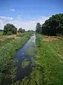
The Marcal one week after the Ajka alumina plant accident
In October 2010, the Marcal was contaminated in a chemical spill by red mud and temporarily suffered massive loss of aquatic life, from which it has since recovered.[1][2]
References
- ↑ Jahn, George (7 October 2010). "Toxic red sludge reaches the Danube River". Yahoo! News. Associated Press. Retrieved 8 October 2010.
- ↑ "Hungarian red mud spill did little long-term damage".
Wikimedia Commons has media related to Marcal.
External links
- Marcal River website (in Hungarian)
This article is issued from Wikipedia. The text is licensed under Creative Commons - Attribution - Sharealike. Additional terms may apply for the media files.