Marktsteft | |
|---|---|
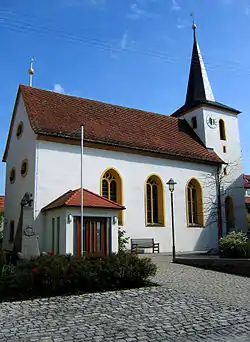 Church of Saint Michael | |
 Coat of arms | |
Location of Marktsteft within Kitzingen district 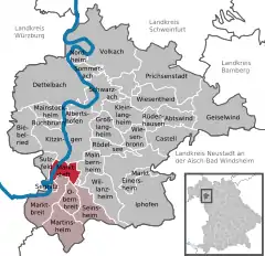 | |
 Marktsteft  Marktsteft | |
| Coordinates: 49°42′N 10°7′E / 49.700°N 10.117°E | |
| Country | Germany |
| State | Bavaria |
| Admin. region | Unterfranken |
| District | Kitzingen |
| Municipal assoc. | Marktbreit |
| Government | |
| • Mayor (2020–26) | Thomas Reichert[1] (CSU) |
| Area | |
| • Total | 10.51 km2 (4.06 sq mi) |
| Elevation | 189 m (620 ft) |
| Population (2022-12-31)[2] | |
| • Total | 1,925 |
| • Density | 180/km2 (470/sq mi) |
| Time zone | UTC+01:00 (CET) |
| • Summer (DST) | UTC+02:00 (CEST) |
| Postal codes | 97342 |
| Dialling codes | 09332 |
| Vehicle registration | KT |
| Website | www.marktsteft.de |
Marktsteft (German: [maʁktˈʃtɛft] ⓘ) is a town in the district of Kitzingen, in Bavaria, Germany. It is situated on the left bank of the Main, 5 km (3 mi) southwest of Kitzingen.
It was the birthplace (1885) of the well-known Second World War general Albert Kesselring.
References
- ↑ Liste der ersten Bürgermeister/Oberbürgermeister in kreisangehörigen Gemeinden, Bayerisches Landesamt für Statistik, 15 July 2021.
- ↑ Genesis Online-Datenbank des Bayerischen Landesamtes für Statistik Tabelle 12411-003r Fortschreibung des Bevölkerungsstandes: Gemeinden, Stichtag (Einwohnerzahlen auf Grundlage des Zensus 2011)
External links
Towns and municipalities in Kitzingen (district) | ||
|---|---|---|
| Coat of Arms of Kitzingen district | |
This article is issued from Wikipedia. The text is licensed under Creative Commons - Attribution - Sharealike. Additional terms may apply for the media files.