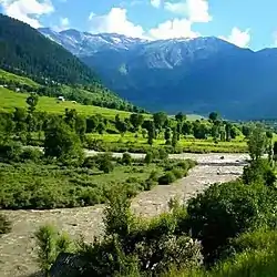
Marwah | |
|---|---|
Valley/Sub-division | |
 Marwah Valley | |
 Marwah Location in Jammu and Kashmir, India | |
| Coordinates: 33°49′00″N 75°54′56″E / 33.8168°N 75.9155°E | |
| Country | India |
| Union territory | Jammu and Kashmir |
| Division | Jammu |
| Region | Chenab Valley |
| District | Kishtwar |
| Area | |
| • Total | 307.35 km2 (118.67 sq mi) |
| Population (2011) | |
| • Total | 35,572 |
| • Density | 120/km2 (300/sq mi) |
| Language | |
| • Spoken | Kashmiri, Kishtwari |
| • Official | Urdu |
| Pin Code | 182205 |
| DDC | Sheikh Zafarullah[1] |
Marwah is a valley and sub-division in the Kishtwar district of Jammu and Kashmir in India.[2] Marwah is surrounded by the Warwan valley to the northwest, Ladakh and Zanskar to the east, Chatroo and Kishtwar to the south, and Anantnag in the west. The area is drained by river Marusudar, which is the largest tributary of Chenab.
The various tourist destinations of Marwah include Tatapani, Kishtwar National Park, Sarasnag, hajan park ,Mudaksar, Nun Kun, Kandinag, Fariabad Yordu Doomail and Cricket Stadium Yordu.
Demographics
Marwah sub division consists of 4 tehsils and 27 villages, according to census 2011.[3]
| S. No. | Village | Administrative Division | Population |
|---|---|---|---|
| 1 | Sonder | Marwah | 3658 |
| 2 | Lopara | Marwah | 3146 |
| 3 | Lohrna | Marwah | 2994 |
| 4 | Chanjer | Marwah | 2174 |
| 5 | Nopachi | Marwah | 2102 |
| 6 | Qaderna | Marwah | 1961 |
| 7 | Yeerdu | Marwah | 1705 |
| 8 | Rinaie | Marwah | 1650 |
| 9 | Janak Pur | Marwah | 1578 |
| 10 | Deharna | Marwah | 1424 |
| 11 | Chicha Dachhan | Marwah | 1389 |
| 12 | Pathgam | Marwah | 1242 |
| 13 | Margi | Marwah | 1207 |
| 14 | Busmina | Marwah | 1041 |
| 15 | Inshan | Marwah | 1031 |
| 16 | Aftee | Marwah | 932 |
| 17 | Choye Draman | Marwah | 920 |
| 18 | Mulwarwan | Marwah | 850 |
| 19 | Tiller | Marwah | 762 |
| 20 | Barayan | Marwah | 761 |
| 21 | Gumri | Marwah | 578 |
| 22 | Sukhnai | Marwah | 508 |
| 23 | Hanzal | Marwah | 472 |
| 24 | Mungli | Marwah | 466 |
| 25 | Nowgam | Marwah | 415 |
| 26 | Dharie | Marwah | 362 |
| 27 | Rekenwas | Marwah | 244 |
Religion
The region has a Muslim majority population, with a significant Hindu minority.[4]
Religion in Marwah (2011)[3]
Language and culture
The vast majority of the population speaks Kashmiri.
Culture is almost similar to that of Kashmir valley.
References
- ↑ "Merge Marwah sub division with China: DDC member". Early Times. 3 June 2021. Retrieved 24 September 2022.
- ↑ "Departments". District Administration Kishtwar, Government of Jammu and Kashmir. Retrieved 24 September 2022.
- 1 2 "Marwah Tehsil Population". Census India. Retrieved 27 July 2021.
- ↑ "Marwah Tehsil Population Kishtwar, Jammu & Kashmir, List of Villages & Towns in Marwah Tehsil". Censusindia2011.com. Retrieved 7 March 2022.
- ↑ C-16 Population By Mother Tongue – Jammu & Kashmir (Report). Office of the Registrar General & Census Commissioner, India. Retrieved 4 December 2021.