| Matarranya | |
|---|---|
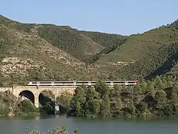
 Bridge over the Matarranya River close to Faió | |
| Location | |
| Country | Aragon, Spain |
| Physical characteristics | |
| Source | |
| • location | Barranc del Salt, Ports de Beseit |
| • elevation | 1,200 m (3,900 ft) |
| Mouth | |
• location | Ebro |
• elevation | 75 m (246 ft) |
| Length | 100 km (62 mi) |
| Basin size | 1,250 km2 (480 sq mi) |
| Discharge | |
| • average | 6.51 m3/s (230 cu ft/s) |
| Basin features | |
| Progression | Ebro→ Mediterranean Sea |
The Matarranya (Spanish: Río Matarraña, Catalan: Riu Matarranya) is a river in the provinces of Teruel and Zaragoza, Aragon, Spain. It begins its course at 1,200 m northeast of the Tossal d'Encanader, Ports de Beseit.[1] limestone massif near La Pobla de Benifassà.
The Matarranya flows roughly from south to north into the Ebro (Ebre), 4 km east of Faió (Fayón). This river gives its name to the Matarranya Catalan language-speaking comarca of Aragon.[2]
Tributaries
- From the left:
- Algars River
- Ulldemó River
- Barranc de Calapatar
- From the right:
- De Pena River
- Tastavins River
See also
- Ports de Beseit
- Matarraña/Matarranya comarca
References
External links
- Turismo de Aragon (in Spanish)
- Matarranya Tourism
- Interpreting avulsion process from ancient alluvial sequences: Guadalope-Matarranya system (northern Spain) and Wasatch Formation (western Colorado)
- Map of the river within the historical comarca
- Effect of floods of different magnitude on the macroinvertebrate communities of Matarranya stream (Ebro river basin, NE Spain)
- Microhabitat Use in a Mediterranean Riverine Fish Assemblage - Fishes of the Upper Matarranya
41°11′00.89″N 00°09′50.51″E / 41.1835806°N 0.1640306°E
This article is issued from Wikipedia. The text is licensed under Creative Commons - Attribution - Sharealike. Additional terms may apply for the media files.