| Mazum Dam | |
|---|---|
 | |
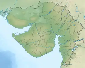 Location of Mazum Dam in Gujarat  Mazum reservoir (India) | |
| Official name | Mazam Dam |
| Coordinates | 23°29′16″N 73°21′06″E / 23.487701°N 73.3515453°E |
| Purpose | Flood Control, Irrigation |
| Construction began | 1979 |
| Opening date | 1984[1] |
| Dam and spillways | |
| Type of dam | Earthen |
| Impounds | Mazum River |
| Length | 2402 m[1] |
| Reservoir | |
| Creates | Mazam Reservoir |
| Total capacity | 1916 TMC[1] |
The Mazum Dam (alternatively Mazam) is built on the small river Mazum in the Aravalli District about 9 km from Modasa, Gujarat, India. The dam supplies water, allowing farmers to harvest their crops, and is also used when nearby towns are running out of water.
References
- 1 2 3 "Mazam Dam". India-WRIS. Retrieved 27 December 2018.
This article is issued from Wikipedia. The text is licensed under Creative Commons - Attribution - Sharealike. Additional terms may apply for the media files.