Mbewuleni | |
|---|---|
 Mbewuleni  Mbewuleni | |
| Coordinates: 31°40′05″S 27°43′01″E / 31.668°S 27.717°E | |
| Country | South Africa |
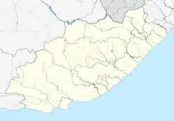
| Province | Eastern Cape |
| District | Chris Hani |
| Municipality | Sakhisizwe |
| Government | |
| • Councillor | ū |
| Area | |
| • Total | 2.30 km2 (0.89 sq mi) |
| Population (2011)[1] | |
| • Total | 233 |
| • Density | 100/km2 (260/sq mi) |
| Racial makeup (2011) | |
| • Black African | 99.6% |
| • White | 0.4% |
| First languages (2011) | |
| • Xhosa | 98.3% |
| • Other | 1.7% |
| Time zone | UTC+2 (SAST) |
Mbewuleni is a remote village in the Sakhisizwe Local Municipality of the Eastern Cape in South Africa. Its primary claim to fame is as the birthplace of former president Thabo Mbeki.
References
- 1 2 3 4 "Main Place Mbewuleni". Census 2011.
Municipalities and communities of Chris Hani District Municipality, Eastern Cape | ||
|---|---|---|
District seat: Queenstown (Komani) | ||
| Intsika Yethu | .svg.png.webp) Chris Hani District within South Africa | |
| Enoch Mgijima | ||
| Engcobo |
| |
| Emalahleni |
| |
| Inxuba Yethemba | ||
| Sakhisizwe | ||
This article is issued from Wikipedia. The text is licensed under Creative Commons - Attribution - Sharealike. Additional terms may apply for the media files.