| McDonald Lake | |
|---|---|
| Rafferty Reservoir | |
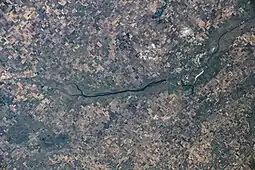 McDonald Lake as seen from the ISS | |
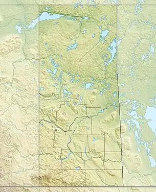 McDonald Lake Location in Saskatchewan  McDonald Lake McDonald Lake (Canada) | |
| Coordinates | 49°11′38″N 103°14′17″W / 49.194°N 103.238°W |
| Type | Reservoir |
| Primary inflows | Souris River, Jewell Creek, and a 10-km diversion channel connecting Boundary and Rafferty Reservoirs, which allows water to be diverted from Boundary Reservoir into McDonald Lake. |
| Primary outflows | Souris River |
| Catchment area | 2,448 km2 (945 sq mi) |
| Managing agency | The Saskatchewan Water Security Agency |
| Built | July 1, 1991 |
| Max. length | 57 km (35 mi) |
| Max. width | 1.2 km (0.75 mi) |
| Surface area | 48.8 km2 (18.8 sq mi) |
| Average depth | 15 m (49 ft) |
| Max. depth | 15 m (49 ft) |
| Water volume | 439,600,000 m3 (356,400 acre⋅ft) |
| Surface elevation | 556 m (1,824 ft) |
| References | [1] |
McDonald Lake, also known as Rafferty Reservoir, is a reservoir in south-east part of the Canadian province of Saskatchewan.[2] It was created when the Rafferty Dam was built on the Souris River in 1994. Before the dam was built that flooded the Souris Valley, McDonald Lake was a small lake and marsh on the valley floor adjacent to the Souris River.
The reservoir provides water to the Shand Power Station and to the city of Estevan. A 10-kilometre long pipeline supplies the power station and a 9.2-km long pipeline, which originates along the Souris River river bed at the bottom of the reservoir, brings water to the Estevan water treatment plant. The water pipeline that brings water to Estevan was completed in 2020 after a three-year project that changed the source of Estevan's drinking water away from Boundary Dam Reservoir.[3]
Mainprize Regional Park
Mainprize Regional Park (49°22′09″N 103°34′56″W / 49.3691°N 103.5821°W) is a park in the rural municipality of RM of Cymri No. 36. The regional park is operated by a park authority with offices in Midale. The park includes an 18-hole golf course, Pederson Place (a 5,000-square-foot (460 m2) multi-purpose hall), a beach area on McDonald Lake, water plant, camp groups, and a residential cottage subdivisions. The park is located near the north-west end of the lake, on the eastern shore.[4]
Rafferty Dam
Rafferty Dam is located at the south-eastern corner of the lake, 4.8 kilometres (3.0 mi) upstream from Estevan. It was built in conjunction with the Grant Devine Dam (formally known as Alameda Dam), which was built further downstream on Moose Mountain Creek, which is a tributary of the Souris River. Both dams are operated by the Saskatchewan Water Security Agency. The dam and reservoir provide flood control along the Souris River, irrigation, and recreation.[5]
The height of the top of the dam is 555 m (1,821 ft) above sea level. The maximum height available for flood control is 554 m (1,818 ft). The normal full supply level is 550.5 m (1,806 ft) and the normal drawdown level is 549.5 m (1,803 ft). The maximum draw down is 547.5 m (1,796 ft) above sea level. At full supply, the reservoir covers an area of 4,881 ha (12,060 acres).[6]
A 10-kilometre long spillway connects the Boundary Dam Reservoir to McDonald Lake, allowing excess water to flow into McDonald Lake. The flow can also be reversed if necessary.
Gallery
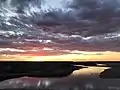 Sunset on McDonald Lake
.jpg.webp) McDonald Lake
McDonald Lake.jpg.webp) McDonald Lake
McDonald Lake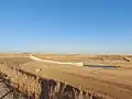 The dam's spillway
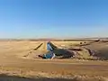 The dam's riparin outlet
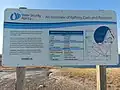 The information sign at the look out at Rafferty Dam
See also
References
- ↑ "McDonald Lake". Mapcarta.
- ↑ "McDonald Lake". Canadian Geographical Names Database. Government of Canada. Retrieved 1 May 2023.
- ↑ "Ceremony for the New Waterline at Rafferty Dam".
- ↑ "Home". mainprizepark.com.
- ↑ "Rafferty-Grant Devine Project". 22 February 2021.
- ↑ "Detailed review of dams and reservoirs coming". 10 August 2011.
External links
- Park Description
 Media related to McDonald Lake (Saskatchewan) at Wikimedia Commons