Mecheri | |
|---|---|
Town | |
 Mecheri Location in Tamil Nadu, India | |
| Coordinates: 11°51′03″N 77°57′23″E / 11.85083°N 77.95639°E | |
| Country | |
| State | Tamil Nadu |
| Region | Kongu Nadu |
| District | Salem |
| Population (2011) | |
| • Total | 25,676 |
| Languages | |
| • Official | Tamil |
| Time zone | UTC+5:30 (IST) |
| Vehicle registration | TN-52,TN-93 |
Mecheri is a town in Mettur taluk, Salem district, Tamil Nadu, India.
Geography
Climate
Mecheri receives little rainfall and has moderately dry weather except during the monsoon season. Summer begins around March. The highest temperatures normally occur during May, which is dry. The climate becomes more temperate in June and July during the pre-monsoon period, and August is overcast and dry. The northeast monsoon occurs from September to November, and the rains disappear by December.
| Climate data for Mecheri, India | |||||||||||||
|---|---|---|---|---|---|---|---|---|---|---|---|---|---|
| Month | Jan | Feb | Mar | Apr | May | Jun | Jul | Aug | Sep | Oct | Nov | Dec | Year |
| Mean daily maximum °C (°F) | 29 (84) |
30 (86) |
33 (91) |
37 (99) |
42 (108) |
38 (100) |
36 (97) |
35 (95) |
33 (91) |
32 (90) |
30 (86) |
28 (82) |
34 (92) |
| Mean daily minimum °C (°F) | 19 (66) |
20 (68) |
22 (72) |
26 (79) |
28 (82) |
27 (81) |
26 (79) |
26 (79) |
25 (77) |
24 (75) |
22 (72) |
21 (70) |
24 (75) |
| Average precipitation mm (inches) | 14.0 (0.55) |
12.0 (0.47) |
24.0 (0.94) |
44.0 (1.73) |
75.0 (2.95) |
48.0 (1.89) |
59.0 (2.32) |
73.0 (2.87) |
122.0 (4.80) |
161.0 (6.34) |
197.0 (7.76) |
92.0 (3.62) |
1,266.9 (49.88) |
| Source: Indian Meteorological Department[1] | |||||||||||||
Demographics
Population
In the 2011 Census of India, Mecheri had a population of 25,676. Males constituted 53 percent of the population, and females 47 percent; 12 percent of the population was under six years of age.[2] Mecheri had a literacy rate of 59 percent, lower than the national literacy rate of 77 percent.[3]
Economy


Livestock
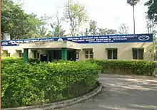
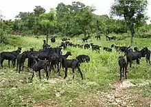
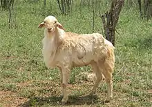
Mecheri is known for its Kurumbai sheep. To develop and encourage sheep farming, the government of Tamil Nadu established the Mecheri Sheep Research Station in 1978 in Mecheri's Pottaneri panchayat.[4]

Culture
Tourist attractions
Mecheri is a holy site.[5] Rajagopuram is the temple's main entrance, and Mecheri has a number of other temples.
Transport


Mecheri is on State Highway 20, the Bhavani-Thoppur road. Thoppur is 20 kilometres (12 mi) from Mecheri. Bhavani, 60 kilometres (37 mi) away, connects to Erode and Coimbatore via NH 544. Scheduled bus service is available to Chennai, Bangalore, Erode, Coimbatore and Mysore from MSS[6] and KPN Travels.[7]

References
- ↑ "Climatological Information for Chennai". Indian Meteorological Department. Archived from the original on 5 February 2009. Retrieved 25 January 2009.
- ↑ "Census of India 2001: Data from the 2014 Census, including cities, villages and towns (Provisional)". Census Commission of India. Archived from the original on 16 June 2004. Retrieved 1 November 2008.
- ↑ "International Literacy Day 2020: Kerala most literate state in India, check rank-wise list". Hindustan Times. 8 September 2020. Retrieved 11 August 2021.
- ↑ "Welcome to TAMILNADU VETERINARY & ANIMAL SCIENCES UNIVERSITY(TANUVAS)". Archived from the original on 9 May 2015. Retrieved 11 May 2015.
- ↑ "Arulmigu Badrakaliamman Temple - Mecheri". Archived from the original on 17 October 2011. Retrieved 11 May 2015.
- ↑ "Mettur Super Service". www.mssbus.com.
- ↑ ":: Welcome to KPN Travels India LTD., ::". Archived from the original on 11 May 2015. Retrieved 15 May 2015.