Catbalogan | |
|---|---|
| City of Catbalogan | |
.jpg.webp) | |
 Flag  Seal | |
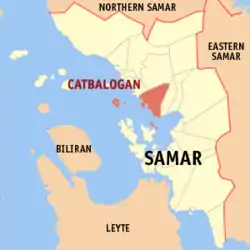
 Map of Samar with Catbalogan highlighted | |
OpenStreetMap | |
.svg.png.webp) Catbalogan Location within the Philippines | |
| Coordinates: 11°47′N 124°53′E / 11.78°N 124.88°E | |
| Country | Philippines |
| Region | Eastern Visayas |
| Province | Samar |
| District | 2nd district |
| Founded | October 1596 |
| Cityhood | June 16, 2007 (Lost cityhood in 2008 and 2010) |
| Affirmed Cityhood | February 15, 2011 |
| Barangays | 57 (see Barangays) |
| Government | |
| • Type | Sangguniang Panlungsod |
| • Mayor | Dexter M. Uy |
| • Vice Mayor | Coefredo T. Uy |
| • Representative | Reynolds Michael T. Tan |
| • City Council |
|
| Area | |
| • Total | 274.22 km2 (105.88 sq mi) |
| Elevation | 93 m (305 ft) |
| Highest elevation | 1,331 m (4,367 ft) |
| Lowest elevation | 0 m (0 ft) |
| Population (2020 census)[4] | |
| • Total | 106,440 |
| • Density | 390/km2 (1,000/sq mi) |
| • Households | 23,107 |
| Demonym | Catbaloganon |
| Economy | |
| • Income class | 5th city income class |
| • Poverty incidence | 19.00 |
| • Revenue | ₱ 953.2 million (2020) |
| • Assets | ₱ 1,525 million (2020) |
| • Expenditure | ₱ 852.5 million (2020) |
| Service provider | |
| • Electricity | Samar 2 Electric Cooperative (SAMELCO 2) |
| Time zone | UTC+8 (PST) |
| ZIP code | 6700 |
| PSGC | |
| IDD : area code | +63 (0)55 |
| Native languages | Waray Tagalog |
| Website | www |
Catbalogan, officially the City of Catbalogan (Waray: Siyudad han Catbalogan; Filipino: Lungsod ng Catbalogan), is a 5th class component city and capital city of the province of Samar, Philippines. According to the 2020 census, it has a population of 106,440 people.[4]
It is Samar's main commercial, trading, educational, financial and political center. The city is the gateway to the region's three Samar provinces.
Catbalogan's patron saint is St. Bartholomew the Apostle whose feast day is August 24.
The Philippine Army's 8th Infantry Division (Stormtroopers) is based at Camp General Vicente Lukban, Barangay Maulong, Catbalogan City. The camp is named in honor of Gen. Vicente Lukbán, a Filipino officer in Gen. Emilio Aguinaldo's staff during the Philippine Revolution and the politico-military chief of Samar and Leyte during the Philippine–American War.[6]
History

Catbalogan was founded in October 1596 by Spanish Jesuit priests and became the capital of the entire island of Samar. Friar Francisco de Otazo, S.J., who arrived in the Philippines in 1596, founded the Catbalogan Mission and was thus the first missionary to bring the Catholic faith to the people of Catbalogan.
In 1627, Catbalogan was raised to the status of residencia (residence or central house) and among its dependencies were Paranas where, in 1629, Fr. Pedro Estrada actively evangelized the area and Calbiga where he took whiterocks or grey limestone to use as building blocks for its church. The church has some arc-like stone roof that was pasted together to dry on each block, giving an arching force to the side. On October 17, 1768, Catbalogan was ceded to the Franciscans who took over from the Jesuits. The first Franciscan parish priest was Fray Jose Fayo, OFM.
During the early days of Spanish colonization of the Philippines in the 16th century, Samar was under the jurisdiction of Cebu but later was declared a separate province. In 1735, Samar and Leyte were united into one province with Carigara, in Leyte, as the capital. The union, however, did not prove satisfactory. In 1768, Catbalogan became the provincial capital when Samar separated from Leyte and became an independent province. Paranas (with Calbiga) was then separated from Catbalogan as an independent town. In 1882, Jiabong (with Motiong) separated from Catbalogan as an independent town.
On December 31, 1898, during the Philippine Revolution, Gen. Vicente Lukban arrived in Catbalogan and put Samar under his jurisdiction.
On January 27, 1900, the Americans captured Catbalogan during the Philippine–American War (1899–1902). On June 17, 1902, a provincial civil government was established on Samar Island by an act of the Philippine Commission with Julio Llorente of Cebu as the first governor of Samar.
On May 24, 1942, during World War II, Japanese forces landed in Barrio Pangdan on early morning and occupied the capital. On October 28, 1944, American and Filipino forces liberated Catbalogan from the Japanese.[7]
In 1948, the barrios of Jiabong, Jiaan, Malino, San Fernando, Casapa, Camoroboan, Lologayan, Magcabitas, Paglayogan, Dogongan, Bayog, and Malobago were separated to form the municipality of Jiabong.[8]
On June 19, 1965, the Philippine Congress, along with the province's three congressmen, Eladio T. Balite (1st District), Fernando R. Veloso (2nd District) and Felipe J. Abrigo (3rd District), approved Republic Act No. 4221 dividing Samar into three provinces, namely Western Samar, Eastern Samar and Northern Samar, respectively. Catbalogan thus ceased to be the capital of the whole island-province after enjoying the prestige of being the premier town of Samar for 197 years since 1768.
On June 21, 1969, under Republic Act No. 5650, Western Samar was renamed Samar with Catbalogan remaining as the capital.
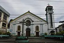
The greatest calamities to occur in Catbalogan were big fires. The April 1, 1957 conflagration, considered as the most destructive one, caused damage to properties in the amount of thirty million pesos. The next was on May 19, 1969, where damage was estimated at twenty million pesos and the more than century-old Saint Bartholomew Roman Catholic Church was razed to the ground. Paradoxically, like the proverbial Phoenix, each time Catbalogan suffered under the throes of these calamities, better buildings and infrastructures emerged from the ashes.
Cityhood
As early as 1960, Catbalogan already agitated to become a city. In 1969, Rep. Fernando P. Veloso sponsored House Bill No. 1867 creating Catbalogan into a city. The bill was being deliberated in the Philippine Senate, but the blaze of 1969 caused it to be shelved. Subsequent efforts were made by Catbalogan political leaders, including former Representative Catalino V. Figueroa, during his term, to make Catbalogan's cityhood dream a reality despite strong and rabid opposition by the League of Cities of the Philippines, particularly Catbalogan City's neighboring Calbayog under the administration of Mayor Mel Senen Sarmiento.
On March 15, 2007, Catbalogan finally attained its cityhood. Under the sponsorship of Senator Alfredo S. Lim and by virtue of Republic Act No. 9391, Catbalogan was converted into a component city known as the CITY of CATBALOGAN following a unanimous vote by the Philippine Senate. Senator Manuel Villar, Jr. (President of the Senate), Congressman Jose De Venecia, Jr. (Speaker of the House of Representatives), Oscar G. Yabes (Secretary of the Senate), Roberto P. Nazareno (Secretary General, House of Representatives) and Gloria Macapagal Arroyo (President of the Philippines) were among its signatories. The residents of Catbalogan overwhelmingly ratified this change through a Comelec plebiscite on June 16, 2007, with over 92% "Yes" votes for cityhood.[9]
However, Catbalogan temporarily lost its cityhood, along with 15 other cities, after the Supreme Court of the Philippines, in a very close 6–5 vote, granted a petition filed by the League of Cities of the Philippines, and declared the cityhood law (RA 9391) which allowed the town to acquire its city status, unconstitutional.[10]
On December 10, 2008, Catbalogan and the other 15 cities affected filed a motion for reconsideration with the court. More than a year later, on December 22, 2009, acting on said appeal, the court reversed its earlier ruling as it ruled that "at the end of the day, the passage of the amendatory law (regarding the criteria for cityhood as set by Congress) is no different from the enactment of a law, i.e., the cityhood laws specifically exempting a particular political subdivision from the criteria earlier mentioned. Congress, in enacting the exempting law/s, effectively decreased the already codified indicators."[11] As such, the cityhood status of Catbalogan was effectively restored.
On August 23, 2010, the court reinstated its ruling on November 18, 2008, causing Catbalogan and 15 cities to become regular municipalities. Finally, on February 15, 2011, Catbalogan becomes a city again including the 15 municipalities declaring that the conversion to cityhood met all legal requirements.
After six years of legal battle, in its board resolution, the League of Cities of the Philippines acknowledged and recognized the cityhood of Catbalogan and 15 other cities.
Infrastructure
- Imelda Park
- Rizal Monument
- The Obelisk
- S.T.E.P. North
- Regional AFP Installation (Camp Lukban)
- Buri Cargo Airport
- Catbalogan City Diversion Road
- Catbalogan Land Transport Terminal
- Catbalogan Fish and Transport Port
Provincial Offices
- Philippine National Police Archived July 12, 2017, at the Wayback Machine (PNPProvincial Office)
- Philippine Statistics Office (PSA/former NSO)
- Department of Education DepEd Secondary (former DECS) W?Samar Division) CHED Office?
- Department of Agriculture (DA Pro)
- Department of Health (DOH Pro)
- Department of Environment and Natural Resources (PENRO)
- Department of Justice (DOJ)
Geography

Barangays

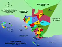
Catbalogan City is politically subdivided into 57 barangays. Each barangay consists of puroks and some have sitios.
- Albalate
- Bagongon
- Bangon
- Basiao
- Buluan
- Bunuanan
- Cabugawan
- Cagudalo
- Cagusipan
- Cagutian
- Cagutsan
- Canhawan Guti
- Canlapwas (Poblacion 15)
- Cawayan
- Cinco
- Darahuway Daco
- Darahuway Guti
- Estaka
- Guindapunan
- Guinsorongan
- Ibol
- Iguid
- Lagundi
- Libas
- Lobo
- Manguehay
- Maulong (Oraa)
- Mercedes
- Mombon
- New Mahayag (Anayan)
- Old Mahayag
- Palanyogon
- Pangdan
- Payao
- Poblacion 1 (Barangay 1)
- Poblacion 2 (Barangay 2)
- Poblacion 3 (Barangay 3)
- Poblacion 4 (Barangay 4)
- Poblacion 5 (Barangay 5)
- Poblacion 6 (Barangay 6)
- Poblacion 7 (Barangay 7)
- Poblacion 8 (Barangay 8)
- Poblacion 9 (Barangay 9)
- Poblacion 10 (Barangay 10 : Monsanto Street)
- Poblacion 11 (Barangay 11)
- Poblacion 12 (Barangay 12)
- Poblacion 13 (Barangay 13)
- Muñoz (Poblacion 14)
- Pupua
- Rama
- San Andres
- San Pablo
- San Roque
- San Vicente
- Silanga (Papaya)
- Socorro
- Totoringon
Climate
| Climate data for Catbalogan (1991–2020, extremes 1949–2020) | |||||||||||||
|---|---|---|---|---|---|---|---|---|---|---|---|---|---|
| Month | Jan | Feb | Mar | Apr | May | Jun | Jul | Aug | Sep | Oct | Nov | Dec | Year |
| Record high °C (°F) | 35.4 (95.7) |
36.0 (96.8) |
37.0 (98.6) |
37.5 (99.5) |
37.9 (100.2) |
38.0 (100.4) |
36.6 (97.9) |
36.0 (96.8) |
36.4 (97.5) |
35.8 (96.4) |
36.0 (96.8) |
34.8 (94.6) |
38.0 (100.4) |
| Mean daily maximum °C (°F) | 30.8 (87.4) |
31.4 (88.5) |
34.1 (93.4) |
33.5 (92.3) |
33.9 (93.0) |
33.4 (92.1) |
32.7 (90.9) |
32.9 (91.2) |
32.8 (91.0) |
32.3 (90.1) |
31.9 (89.4) |
31.2 (88.2) |
32.6 (90.7) |
| Daily mean °C (°F) | 26.7 (80.1) |
27.0 (80.6) |
28.6 (83.5) |
28.8 (83.8) |
29.5 (85.1) |
29.2 (84.6) |
28.8 (83.8) |
29.1 (84.4) |
28.9 (84.0) |
28.4 (83.1) |
27.8 (82.0) |
27.3 (81.1) |
28.4 (83.1) |
| Mean daily minimum °C (°F) | 22.7 (72.9) |
22.6 (72.7) |
23.2 (73.8) |
24.1 (75.4) |
25.0 (77.0) |
25.0 (77.0) |
24.9 (76.8) |
25.3 (77.5) |
24.9 (76.8) |
24.4 (75.9) |
23.8 (74.8) |
23.4 (74.1) |
24.1 (75.4) |
| Record low °C (°F) | 16.1 (61.0) |
17.0 (62.6) |
18.1 (64.6) |
17.9 (64.2) |
20.8 (69.4) |
20.0 (68.0) |
21.0 (69.8) |
20.0 (68.0) |
21.1 (70.0) |
20.6 (69.1) |
18.9 (66.0) |
18.0 (64.4) |
16.1 (61.0) |
| Average rainfall mm (inches) | 295.7 (11.64) |
208.3 (8.20) |
190.9 (7.52) |
123.7 (4.87) |
179.0 (7.05) |
229.8 (9.05) |
291.5 (11.48) |
195.7 (7.70) |
280.3 (11.04) |
299.4 (11.79) |
292.8 (11.53) |
403.9 (15.90) |
2,991 (117.76) |
| Average rainy days (≥ 1.0 mm) | 16 | 12 | 13 | 11 | 12 | 15 | 17 | 12 | 15 | 19 | 19 | 20 | 181 |
| Average relative humidity (%) | 85 | 82 | 81 | 79 | 79 | 81 | 82 | 80 | 81 | 84 | 85 | 86 | 82 |
| Source: PAGASA[12][13] | |||||||||||||
Transportation

For decades, Catbalogan City has served as Samar island's main maritime transport gateway as interisland vessels made its port of call at Catbalogan City Seaport before proceeding to Tacloban City. As the advent of land transport became possible, the interisland maritime transport slowly ceased to operate.
Today, Catbalogan City is a major landport terminal and stopover for interisland bus lines coming and going between Luzon and Mindanao passing through the bridged island of Leyte and Samar.
Catbalogan Airport, also known as Buri Airport is the main airport of Catbalogan City.
Demographics

| Year | Pop. | ±% p.a. |
|---|---|---|
| 1903 | 7,758 | — |
| 1918 | 13,544 | +3.78% |
| 1939 | 26,654 | +3.28% |
| 1948 | 26,839 | +0.08% |
| 1960 | 34,873 | +2.21% |
| 1970 | 49,109 | +3.48% |
| 1975 | 52,384 | +1.30% |
| 1980 | 58,737 | +2.31% |
| 1990 | 70,470 | +1.84% |
| 1995 | 76,324 | +1.51% |
| 2000 | 84,180 | +2.12% |
| 2007 | 92,454 | +1.30% |
| 2010 | 94,317 | +0.73% |
| 2015 | 103,879 | +1.86% |
| 2020 | 106,440 | +0.48% |
| Source: Philippine Statistics Authority [14][15][16][17] | ||
Economy
.jpg.webp)
- Bank of the Philippine Islands
- Chinese Chamber of Commerce, Philippines
Clinic and Medical Facilities
- Catbalogan Puericulture Center
- Samar Provincial Hospital
- Samar Doctors Hospital (Maulong)
- Samar Medical Hospital (Diversion Road)
Education
Preparatory, Primary and Intermediate School
- Dorcas Day Care Center
- Chinese Chamber of Commerce Kinder & Primary School
- Catbalogan Central Elementary School
Junior & Senior High School
Regional Junior & Senior High School
Colleges and universities
- Saint Mary’s College of Catbalogan
- Samar College
- Samar State University
- University of Payao (alang EVR)
Headlock moments 2023 (november 4, 2023 - the day he kissed my lips)
References
- ↑ City of Catbalogan | (DILG)
- ↑ https://dilg.gov.ph/local-officials/master DILG Masterlist of Officials
- ↑ "2015 Census of Population, Report No. 3 – Population, Land Area, and Population Density" (PDF). Philippine Statistics Authority. Quezon City, Philippines. August 2016. ISSN 0117-1453. Archived (PDF) from the original on May 25, 2021. Retrieved July 16, 2021.
- 1 2 Census of Population (2020). "Region VIII (Eastern Visayas)". Total Population by Province, City, Municipality and Barangay. Philippine Statistics Authority. Retrieved July 8, 2021.
- ↑ "PSA Releases the 2018 Municipal and City Level Poverty Estimates". Philippine Statistics Authority. December 15, 2021. Retrieved January 22, 2022.
- ↑ "Catbalogan, Samar". heyplaces.ph.
- ↑ "Communique No. 934, October 28, 1944 | GOVPH". Official Gazette of the Republic of the Philippines. Retrieved April 10, 2022.
- ↑ "An act creating the municipality of Jiabong, province of Samar". LawPH.com. Archived from the original on July 10, 2012. Retrieved April 8, 2011.
- ↑ "Becoming Catbalogan City". www.samarisland.com. Retrieved December 27, 2018.
- ↑ Rempillo, Jay B. (November 18, 2008) SC Voids 16 Cityhood Laws. Court News Flash November 2008, Supreme Court of the Philippines
- ↑ Pulta, Benjamin B. (December 23, 2009) SC reverses self, upholds creation of 16 cities. tribuneonline.org
- ↑ "Catbalogan, Western Samar Climatological Normal Values 1991–2020" (PDF). Philippine Atmospheric, Geophysical and Astronomical Services Administration. Archived from the original (PDF) on March 2, 2022. Retrieved June 24, 2022.
- ↑ "Catbalogan, Western Samar Climatological Extremes" (PDF). Philippine Atmospheric, Geophysical and Astronomical Services Administration. Archived from the original (PDF) on March 7, 2022. Retrieved June 24, 2022.
- ↑ Census of Population (2015). "Region VIII (Eastern Visayas)". Total Population by Province, City, Municipality and Barangay. Philippine Statistics Authority. Retrieved June 20, 2016.
- ↑ Census of Population and Housing (2010). "Region VIII (Eastern Visayas)" (PDF). Total Population by Province, City, Municipality and Barangay. National Statistics Office. Retrieved June 29, 2016.
- ↑ Censuses of Population (1903–2007). "Region VIII (Eastern Visayas)". Table 1. Population Enumerated in Various Censuses by Province/Highly Urbanized City: 1903 to 2007. National Statistics Office.
{{cite encyclopedia}}: CS1 maint: numeric names: authors list (link) - ↑ "Province of Samar (Western Samar)". Municipality Population Data. Local Water Utilities Administration Research Division. Retrieved December 17, 2016.
- ↑ "Poverty incidence (PI):". Philippine Statistics Authority. Retrieved December 28, 2020.
- ↑ "Estimation of Local Poverty in the Philippines" (PDF). Philippine Statistics Authority. November 29, 2005.
- ↑ "2003 City and Municipal Level Poverty Estimates" (PDF). Philippine Statistics Authority. March 23, 2009.
- ↑ "City and Municipal Level Poverty Estimates; 2006 and 2009" (PDF). Philippine Statistics Authority. August 3, 2012.
- ↑ "2012 Municipal and City Level Poverty Estimates" (PDF). Philippine Statistics Authority. May 31, 2016.
- ↑ "Municipal and City Level Small Area Poverty Estimates; 2009, 2012 and 2015". Philippine Statistics Authority. July 10, 2019.
- ↑ "PSA Releases the 2018 Municipal and City Level Poverty Estimates". Philippine Statistics Authority. December 15, 2021. Retrieved January 22, 2022.
External links
- Official website
- Philippine Standard Geographic Code
- Philippine Census Information
- Local Governance Performance Management System
- The Supreme Court declares 16 cityhood laws unconstitutional
- Press Statement of the City Government of Catbalogan on Cityhood Issue Archived January 1, 2009, at the Wayback Machine
- SC: Cityhood Laws Constitutional – Supreme Court of the Philippines Court News Flash December 21, 2009

